Early Anstey Trail
Introduction to Anstey before 1837
The earliest recorded settlement in Anstey was in the Saxon period of the 5th – 8th centuries. These people gave the settlement the name of ‘Hanstige’, which meant ‘the high path’.
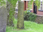
The oldest remaining structure in the village is the remains of the Saxon preaching stump in St Mary’s Churchyard.
However, there is evidence of Roman occupation. The path over the Packhorse Bridge on the Bottom Green is believed to be Roman and an excavation of the land behind Bradgate Road in 1985 showed evidence of a Roman trackway.
In the Domesday Survey of 1086, the village was known as ‘Anstige’ meaning ‘the narrow forest track’ and had a population of 21 households, probably around 60-80 inhabitants.
More evidence of early occupation was found in 2002 when Miss Pratt’s Field on Cropston Road (where the Co-op is now) was excavated and the foundations of a 12th century structure were found.
By the 15th century records show that the name had become ‘Anesty’, the spelling had changed again by 1540 when it was recorded as ‘Anstie’ in Henry VIII’s Muster Roll. The ‘Ansty’ spelling first appears in the 17th century and continued until the 20th century when the ‘e’ was inserted to distinguish the village from Ansty near Coventry.
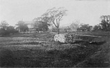
From Saxon times the land was open and worked in common which meant the land that was cultivated was worked as a strip and furrow system, an example of which is the field bordering Leicester Road previously known as The Millfield. Each man had several widely separated long, narrow pieces of land which measured 16’ x 220 yards and were separated by drains of furrows. The standing stone in the left- hand corner of the field is believed to be an ancient marker.
At the time of the dissolution of the monasteries in 1539 part of Anstey belonged to the Priory of Ulverscroft when it was transferred to the crown. In 1609 parcels of the land were sold to local Yeomen.
The landscape changed again in 1761 after The Enclosure Act when many of the small strips of land were amalgamated into larger areas and fields.
By the 18th century most of the land was owned by local farmers. Anstey became a village with two nuclei, one around the Top Green and the other around St Mary’s Church. A third nucleus later developed around The Nook. All three were joined by Main Road (now Bradgate Road) and it was here that many of the village services were found.
It is your responsibility to be aware of whether you are allowed to access any area, to follow the Highway Code, and to be observant of any hazards which may be present along or near your route.
If you experience any issues while following the trail please Contact Us and provide a description.
We hope you enjoy the trail and we would really appreciate your feedback.
Map showing Start of Trail
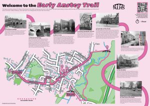
Map view of the Early Anstey trail starting point
Street view of the Early Anstey trail starting point
Clicking the links will either open a new tab on your browser or the Google Maps app
Begin the Trail on the Bottom Green, standing on the Packhorse Bridge with your back to the village.
 The Lower or Bottom Green is one of Anstey’s two ‘Greens’. The other, the Top Green will be visited later in the trail.
Anstey (Rothley) Brook runs through here and there are two bridges to be seen.
The main road bridge is the third bridge built in this position. The first was a stone bridge built to replace a ford.
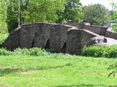
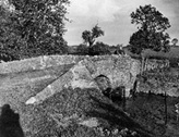
 The other bridge spanning the brook is the Packhorse Bridge, (where you are standing). It is one of two such bridges that are found in Anstey.
One of the oldest structures in the village, it is believed to date from around 1500, although the track itself is probably much earlier, possibly Roman.
It is one of the best-preserved packhorse bridges in Britain. Note the V shaped features which enabled people to move out of the way of the laden horses as they passed. Hence its name.
Walk over the Packhorse Bridge. Turn right into the small field with picnic tables and stand with your back to the brook and look to the right.
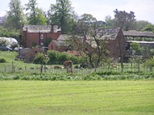
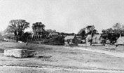
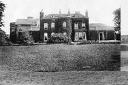 Just beyond where the A46 roundabout is now, a large house named Anstey Pastures stood.
It was built in 1833 by the descendants of Thomas Martin who had had land leased to him by Elizabeth 1 in 1588 and was later sold to a Robert Martin by James 1.
It is probable that the Martin family first lived in The Old Ship on Bradgate Road.
When the Martin family moved to ‘The Brand’ at Woodhouse Eaves in 1892 The Pastures was bought by William Viccars, a hosiery manufacturer and vice chairman of the new Great Central Railway.
The building finally disappeared when the new A46 was built in 1995.
All that remains is the lodge that can be seen on the corner where Gynsill Close meets the roundabout.
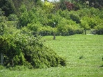 The field closest to The Green was previously known as the Millfield and is a good example of a ridge and furrow system dating back to Saxon times.
Note the lines of ridges across the field.
In this system, each man had several long, narrow pieces of land measuring 16’ x 220 yards which were separated by drains or furrows.
A standing stone, in the left- hand corner of the field, is believed to be an ancient marker.
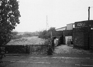
 To the right, in the distance, can be seen Anstey Mill.
The earliest date for the mill at Anstey is 1306, but it is thought that there must have been one in existence even earlier.
There is written reference to a mill and attached meadow producing rents of 50 shillings in 1341 and 33 shillings and 4 pence in 1477.
The present building is believed to have been built about 1800 when the stream may have been widened and the bank built up to provide sufficient water to drive a larger waterwheel.
It ceased work in the 1950s and is now housing.
Retrace your steps over the Packhorse Bridge and pass in front of the row of terraced houses. Cross the road, go across the field with the pylon and follow the footpath along the brook until you reach another Pack horse Bridge. You are now in Castle Hill Country Park. For an alternative route you can turn left to the Nook and then follow Cropston Road until you reach Sheepwash Lane. Walk down until you reach the bridge.
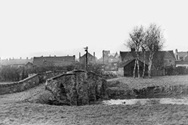
 This bridge is known as Sheepwash Bridge, King William’s Bridge or The Dambridge.
It is believed that the brook could be dammed at this point and used as a sheep wash. Recent excavations showing possible evidence of this can be seen.
If you turn right, at the bend, there is evidence of brickwork in the path and then, if you go into the bushes on the left-hand side, you can see the sheepwash.
The lane was once the main road from Leicester to Bradgate house (now Bradgate Park)
When William III decided to visit the Grey Family at Bradgate House in 1696, it was realised that neither of the bridges into Anstey were wide enough for the king’s coach to pass; it was decided this would be the easiest bridge to widen. Hence the name.
There is an information board by the bridge, erected by Leicester City Council as this side of the brook is in Leicester.
The footpath straight on was originally intended, in the 1761 Enclosure Act, to be the main road to Thurcaston.
Turn left over the bridge and follow the path to Cropston Road. Cross over the road and turn left. Continue until you reach a footpath on the right, between a row of 19th century terraced houses on the left and 1960’s houses on the right.
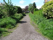 This footpath is known as The Slang.
It was constructed as part of an original Enclosure Road in the 17th century from Bradgate Estate (now Bradgate Park) to Leicester via Beaumont Leys, as a means of connecting a number of large estates in the area. Originally it was planned to continue down Sheepwash Lane and it would have been wider.
The name Slang is of Anglo-Saxon origin meaning ‘long narrow strip of land to rest the animals overnight.’
As the Slang was gated at the top and bottom until the 1920s, it is believed that this was indeed used as a safe space to house animals overnight.
Continue to walk along Cropston Road towards the village centre.
 The road continues past a series of terraced houses. The block (just before Gladstone Street) was, with the exception of a few farms, the end of the village.
 Just before the Co-op, you reach a row of terraced houses.
These are named Gladstone Cottages and originally continued at a right angle. One of the now demolished houses is said to have been the site of an Anstey poor house.
Although records show that Anstey had a workhouse and a number of poor houses, there is no definite evidence to where these may have been.
 The buildings both sides of the Co-op site would have been cottages; one of which, owned by Jack Smith is known to be one of the last framework knitting cottages in the village and had the characteristic long windows which allowed optimum light to enter.
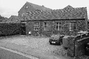
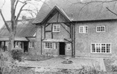
 The next group of buildings, on your right, now a gated residential complex, was one of Anstey’s many farms, Elm Farm.
Sam Burchnall, a major landowner in the village, first moved into the 17th century farmhouse, while the adjacent farmhouse, which appears in the Rate Books for the first time in 1834 was being built.
The property remained in the family until the death of the last inhabitant when the house and all of the outbuildings were sold. It was subsequently restored and developed in 2004.
The 17th century farmhouse became known as the ‘Mews’. There is evidence of the roof being raised to provide an upper floor, together with the period diaper brickwork and the bricked-in window which was probably the result of avoiding the ‘window tax’ imposed by King William III in 1696. A tax that gave rise to the phrase ‘daylight robbery’.
 The Co-op was built on a field belonging to the farm and was known locally as ‘Miss Pratt’s Field’; Miss Pratt being the last occupant of ‘The Elms’. During an archaeological dig on the field in 2002, the foundations of a medieval 12th century structure were found which is believed to be Anstey’s oldest recorded building. A plaque on the wall records this.
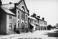 The Chinese Takeaway is on the site of Anstey Methodist Church, which originally served the Primitive Methodist movement. The church was built in 1870 to replace an earlier 1840 building and was extended in 1872 using bricks made at Whitwick Colliery. Services continued until 1970 when worship was stopped due to the poor condition of the building and it was demolished in 1973.The Methodist congregation subsequently held their services in St Mary’s Church until 1988, when the Sunday School building on the opposite side of Cropston Road was converted to a place of worship. The foundation stones for this building were laid on 25th June 1892 by members of the Methodist Church, most of whom were prominent Anstey citizens.
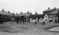
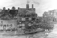
You have reached The Nook which is now the main focus of the village.
 The Nook originally joined Anstey’s two main roads – Main Street (now Bradgate Road) and Cropstone Road (now Cropston Road).
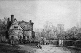
The 1761 enclosure map of Anstey shows a small structure marked in the centre of the Nook, where the roundabout is today, and labelled ‘Stamford’.. There is no record of what this building was, but speculation is that it could have been a market hall or cheese market.
More probably it was a lock up somewhere to hold people until they were able to be removed to a court or to hold drunks overnight until they were released next day.
The Earl of Stamford was a major landowner in the area at this time.
 Until the 1920s The Nook was a wide-open space surrounded by cottages; often used as a playground for the children of the village. Over the years it has replaced Main Street (Bradgate Road) as the focus of the village.
The early buildings around The Nook were cottages, many of them thatched. A number of these were built with steps to prevent them being flooded. These later became shops in the early 20th century and most of the shop keepers lived over the premises.
As there was no decent road into Anstey until the 20th century, most shopping was done locally. This meant there was a vast array of shops, from food to clothes. Much of the produce was supplied locally which accounts for the large number of farms, bakers, butchers and dairies recorded.
Many of these buildings have now disappeared, however, the café on the corner of Cropston Road gives an indication of how the original buildings would have looked. Even though some shop fronts have changed, the roof line of many of these premises remain.
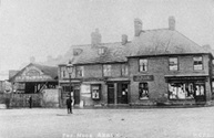
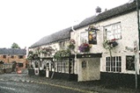
 The Coach and Horses Public House, built in its present form around 1895 when the business was taken over by Marstons Brewery and the much earlier building, predating the 1841 census, was demolished.
Part of the car park was originally the stables for horses.
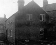
Go into the car park which is signposted from The Nook, just past the LOROS Shop.
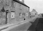
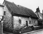
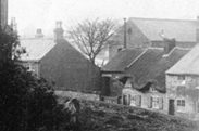
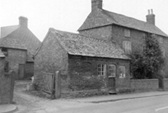
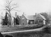
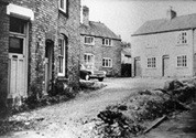 Part of the village car park was originally an area of houses known as Nook Yard. A number of these houses were converted in Victorian times from cruck frame cottages.
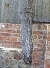
Just visible in the righthand window of the second photo, is the cruck, the remains of which is now the stump by the wall on the left -hand side.
Leave The Nook and go up Bradgate Road.
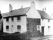
 Numbers 4 and 6 Bradgate Road, on the left- hand side, are built on the site of a house called The Old Ship.
This was built around 1450 and was regarded as one of the best timber framed medieval cottages in the county. It is believed it was built by a prominent Abbey tenant as Anstey was, at that time, under the jurisdiction of Leicester Abbey and there is evidence that it was probably the Martin Family who lived here, prior to The Pastures which was built in 1833.
The building was demolished 1955 even though a preservation order had been put on it. The building that replaced it, incorporated some nautical features in its construction in memory of its predecessor’s name.
 Further up, on the same side, were very old, thatched and timber framed cottages known as ‘The Bank’. These were demolished in the 1950s a few years after The Ship.
On the opposite side of the road, the ‘modern’ buildings are built on the site that was originally Cadeby’s Farm and cheese dairy.
Follow Bradgate Road, past The Hare and Hounds Public house, until you reach the gate to St Mary’s Church.
 You are now in Anstey’s medieval centre.
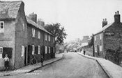
Originally named Main Street, Bradgate Road was the main street through the village, joining the now Cropston Road through the Nook and Newtown Lane towards Newtown Linford.
Until the latter part of the 19th century this area would have been fields and farms, interspersed with cottages.
It was from this main road that most of the village roads radiated when Anstey was a nucleated village of which St Mary’s Church was the centre.
It was the area where most of the population originally lived; the village only expanding with the coming of the boot and shoe industry in the 19th century.
A number of the original buildings remain, although most now have different uses with many being renovated for residential use.
 The Hare and Hounds is another of Anstey’s old public houses, which was a coaching inn, pre-dating the 1841 census.
It was owned by Pettifor’s Steam Brewery until 1900 when Marstons took over the brewery.
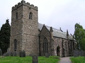 The first church was built on this site in the 14th or 15th century. The restored tower and doorway at the rear of the church are the only part of that building remaining. The rest of the church was rebuilt at a cost of £4,000 between 1845 and 1846, at the expense of the then rector, Reverend Richard Waterfield B.D., to accommodate Anstey’s rising population.
 The churchyard was the place of burial for all Anstey residents until 1888 when the new Anstey Cemetery was opened on Groby Road (then Groby Lane) at the edge of the village. This land was given to the village by Rev W Roby Burgin in 1886 when it was realised that there was very little space remaining in the churchyard.
Near the Bradgate Road wall can be found the Saxon Preaching Stump.
This is the oldest structure in the village and is a good example of a standing cross marking a graveyard. It includes a socket stone and part of a shaft.
 Many notable Anstey families are buried in the churchyard. In days gone by the wealthiest people were buried either inside the church, or as near to the church entrance as possible.
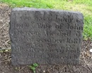
The oldest grave is that of John Deacon who died in 1681.
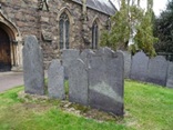 The large tomb that is surrounded by rails, is Mary Heard’s of Heard’s Farm, which, along with other headstones, contains three generations of the Heard Family.
Nearby are the Martin Family graves.
The village Pauper Graves are located on the north side of the churchyard. It is where the poor of the parish were buried in unmarked graves and is the burial place of Ned Ludd, one of Anstey’s most well-known residents.
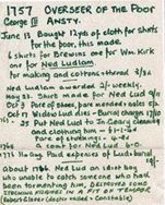 Ned Ludd is believed to be Edward Ludlam who lived in Anstey in the mid-18th century.
Records show that he was of lowly birth, probably of low intelligence and frequently received help from the village poor relief.
It is believed that he destroyed some stocking frames in a fit of temper after being unable to catch someone who had been tormenting him.
Parish records show that the village paid 19/- for his burial on the 31st August 1776.
Stocking frame workers took this name and much later in the 19th century, when in protests with their managers, they destroyed stocking frames and called themselves Luddites.
There is a separate Church and Churchyard trail.
Follow the path round the back of the church and go through the gate into Church Lane.
 Church Lane, another of the ancient roads in Anstey, is situated next to the church and was part of the medieval centre of the village.
Some of the surviving houses in Church Lane were built in the late 19th or early 20th century for the growing population of workers in the village boot and shoe industries. There were a number of alleys and yards with names such as Kidney Bean Alley, Wells Yard and Clarkes Yard as well as Papermill Row. A large number of these houses have now been replaced with modern builds. The numbering of the houses indicates how many of the original have disappeared since 1923.
 The house next to the church was where the curate, who assisted the rector, lived. This meant he was close to the church. Originally a door would have led straight onto the churchyard. Although this is now blocked up, the outline can still be seen.
 On the opposite side of the road are St Mary’s Church Rooms.
Built as the schoolrooms of St. Mary’s Church in 1833, the building was used as the first purpose-built establishment for the education of children in the village, known as the National School.
Following the Elementary Education Act of 1870, the Bradgate Road Board School, known as the ‘Godless School’, was built in 1872 and, despite bitter opposition, St Mary’s National School closed in 1880.
 The building next door was the village Adult School.
This building has had a long and varied life. It was built in the mid-19th century and was used as a papermill around 1875 –1878, hence ‘Papermill Row’ behind where the library is now. It then became a boot and shoe factory, followed by the Adult School & Institute for many years. After WWII the building was an extension for the growing Artisan Press which was based on Leicester Road.
 The garage, next to the Victorian terrace, was built around 1906 by Maurice Reeson to house his horse drawn coach and later his motor bus ‘John Bull’, which was one of the first motorised buses in Leicestershire. This business was taken over in 1911 by Johnny Hutton who garaged his coaches and delivery vans on this site for many years.
The building on the corner of Caters Close, was built about 1830 to replace the yeoman’s timber- framed farmstead that stood on the site next to it. Note the brickwork on the former stables.
At the end of Church Lane, turn right, returning to Bradgate Road.
 Follow the road up the hill, passing the sites of some of the original farms and services of the village.
Heard Farm, on the corner with Groby Road, was built in 1767 for Mary Heard, the daughter of John Heard, a gentleman from Billesdon and his wife Ann. Mary was one of the two main landowners in Anstey.
When she died in 1803, unmarried, she left £600 to be invested and the income be divided between three parishes, Anstey being one of them. She directed that this was to be used to buy shirts and shifts for the poor.
 The second farm, The Limes, just inside Groby Road, was built in the late 16th or early 17th century.
Both farms remained as working farms until late into the 20th century.
Continue to follow Bradgate Road until you reach the Top Green.
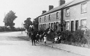
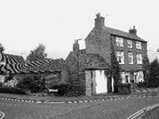
 This area, another of Anstey’s ‘Greens’, known as The Green or The Top Green, was one of the main nuclei of the village.
The area was mentioned on the Enclosure Map of 1761 when it was common land.
Originally completely rural, The Green was surrounded by farms and cottages, some thatched and some slated, some dating to the 15th century.
 On the right- hand corner of Hollow Road there was a cottage where a Mrs Levis ran a Dame School. One of the first educational establishments in Anstey, it was a forerunner of an organised education system for the village children.
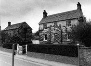
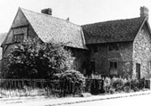
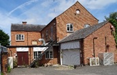
 Green Farm is said to be the oldest domestic building in the village and parts of it are proved to date to the 15th century. The more modern house adjoining it was built about 1800.
The farm originally belonged to the Martin Family and then by subsequent families until farming ceased in 2002.
The white building at the far side of The Green, Manor Farm, belonged to Ulverscroft Abbey until the land was possibly allotted to the 7th Earl of Stamford (Grey Family of Bradgate) as a result of the Enclosure Award in 1762.
In November 1925 the farm was bought, at the Bradgate Estate sale, by George Pettifor for his son William for £3000. It was later run by Mr Wilf Poole.
 In the centre of The Green is the village well. It is believed that the wall surrounding it is medieval.
Bradgate Road bisects the grass areas of The Green and continues towards Newtown Linford. Until 1950 part of this area was within the Newtown Linford boundary.
You have completed the Early Anstey Walk
Time: Approx. 1 hour