Education in Anstey Trail
Introduction to Education in Anstey
Education in Anstey can be divided into five distinct phases.
Until the beginning of the 19th century there was very little formal education and any that took place would be at a dame school.
There were three dame schools in Anstey.
These would be privately owned, run by a local woman in her own house, for a small fee.
Sometimes the children would be taught basic maths and English and perhaps knitting and sewing, but generally the establishments were no more than child minding.
Most of the pupils would have been girls; boys would have been expected to work, at least part of the day, from an early age.
The 2nd phase was in 1811 when the National Society for Promoting Religious Education was established. This society promoted the wider education of children and believed religion should be its foundation and should be the first thing to be taught to the poor.
This meant the schools were usually run by the local vicar and members of the Church of England.
The national school in Anstey was opened in 1833 in a newly built building in Church Lane and was really an extension of Sunday School as we know it today.
Few parents were willing to send their children as they preferred to have them working and those who did encouraged them to take their work with them.
It was usual for the girls to take stockings to seam or to make boot linings.
The 3rd phase was the 1870 Education Act, which made provision for elementary education for all children up to the age of 10. In Anstey it was decided to make provision to 13 years old.
School boards were established to oversee the building and supervision of the schools and Anstey School Board was one of the earliest. Bradgate Road Board School was opened in March 1874.
It was up to the individual school boards as to whether schooling would be compulsory and if school fees would still be charged.
In Anstey, education was made compulsory and 2 pence per week was charged until 1891.
Not all children were full timers, many were part timers. These children either attended school half day every day or a full day every other day. The rest of the time they would be working, often on their full time days as well, before and after school.
The 4th phase was in 1896 when a 5-room school opened in Latimer Street. In 1903 it ceased to be run by the school board and was transferred to Leicestershire County Council.
The school was extended in 1912 due to demand for places when a further building was erected on the other side of the jitty.
In 1928 the junior and senior schools were amalgamated to form an elementary school and in 1967 the infant and junior schools were combined.
The 5th phase was the founding of new schools in the 20th century.
Anstey Martin, named after the Martin family, was opened in 1956 as an elementary school, to free up space at Latimer Street School.
Finally, in 1977, Woolden Hill Primary School was opened to address the growing number of children on the other side of the village.
The other educational site you will visit on the trail is that of Chard’s Private School in Albion Street.
This was opened by Julia Chard after the death of her husband, Albion, who had been the first headteacher of Bradgate Road School.
It is your responsibility to be aware of whether you are allowed to access any area, to follow the Highway Code, and to be observant of any hazards which may be present along or near your route.
If you experience any issues while following the trail please Contact Us and provide a description.
We hope you enjoy the trail and we would really appreciate your feedback.
Map showing Start of Trail
Map view of the Education in Anstey Trail starting point
Street view of the Education in Anstey Trail starting point
Clicking the links will either open a new tab on your browser or the Google Maps app
Begin the Trail at the start of the junction of Forest Gate and Bradgate Road on the Top Green.
 This area is one of Anstey’s two ‘greens.’ Known as The Green or The Top Green, it was one of the main parts of the village.
The area was mentioned on the Enclosure Map of 1761 when it was common land known as High Leys and survives as such today.
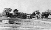
Originally very rural, The Green was surrounded by farms and cottages, some thatched and some slated, some dating from the 15th century. The large Georgian House in front of you being an exception.
 On the right corner of Hollow Road there was a cottage where a Mrs Levis ran a dame school in the late 18th, early 19th century. This was one of the first educational establishments in Anstey and was the forerunner of an organised education system for the village children. It existed until more formal education was established.
Dame schools would have been privately run, for a small fee. The children may have been taught basic reading and arithmetic and sometimes writing, girls might do sewing or knitting.
Often it was little more than child minding.
This was one of three dame schools in Anstey.
The other two were Mrs Westmoreland on Cropston Road and Mrs Widdowson on Groby Lane (Road).
Two quotes describe the extent of the education the children received.
She was a very old lady, sweet and pleasant. The children sat on stools, had slates and pencils and there was a ball frame.
After dinner, I used to stand on a little stool and comb the teacher’s hair whilst she had a nap.
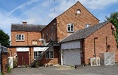
 Green Farm is said to be the oldest domestic building in the village and parts of it have been proven to date from the 15th century. The more modern house adjoining it was built about 1800.
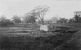 In the centre of The Green is the village well. It is believed that the wall surrounding it is medieval.
Bradgate Road bisects the grass areas of The Green and continues towards Newtown Linford. Until 1950 part of this area was within the Newtown Linford Parish boundary.
Follow Bradgate Road down the hill, past The Crown public house, on your right, until you reach Church Lane.
 Originally named Main Street, Bradgate Road was the main street through the village, joining the now Cropston Road through the Nook one way and Newtown Lane towards Newtown Linford the other.
It was from this main road that most of the village roads radiated when Anstey was a nucleated village and St Mary’s Church was the centre of the medieval village.
Until the latter part of the 19th century this area would have been fields and farms, interspersed with cottages.
It was the area where most of the population originally lived, the village only expanding with the coming of the boot and shoe industry in the 19th century.
A number of the original buildings remain, although most now have different uses with many being renovated for residential use.
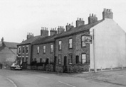
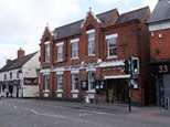
 The Crown Inn on the right-hand side is one of the four main public houses that there were at one time in Anstey, probably run by Anstey’s Steam Brewery, before they were taken over by other breweries such as All Saints Brewery. It is said to be Anstey’s oldest public house, possibly dating back to the 1700s.
The brewery, established in the 1840s by Samuel Burchnall and later taken over by Daniel Pettifor, was built back from the road with cottages for the workers in front of it. It is now the site of Pettifor Court Retirement Complex on the left-hand side of the road.
 Next to The Crown, were two rows of back-to-back houses, with a shared row of earth closets. They were built by the Pettifor family for their brewery workers and were known as Pett’s front and backs. These were demolished in the 1970s and replaced with the modern houses you can see today.
 Most of the buildings on the left-hand side were cottages or shops.
One exception was the old Wesleyan Church, now a private residence. This building replaced an earlier chapel on Groby Road in 1895 and remained in use until 1940 when the church closed as a result of falling congregations and the union with the Primitive Methodist Church on Cropston Road.
Turn left into Church Lane.
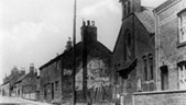
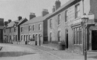
 Church Lane, one of the ancient roads in Anstey, is situated next to the church and was part of the medieval centre of the village.
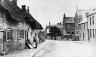
Some of the surviving houses in Church Lane were built in the late 19th or early 20th century for the growing population of workers in the village boot and shoe industries. There were a number of alleys and yards leading off, with names such as Kidney Bean Alley, Wells Yard and Clarkes Yard as well as Papermill Row. A large number of these houses have now been replaced with modern builds. However, enough remain to give an idea of what the area would have been like. The numbering of the houses indicates how many of the original have disappeared since 1923.
 The house next to the church was where the curate, who assisted the rector, lived. This meant he was close to the church. Originally a door would have led straight onto the churchyard. Although this is now blocked up, the outline can still be seen.
 On the opposite side of the road are St Mary’s Church Rooms.
Built as the schoolrooms of St. Mary’s Church in 1833, the building was the first purpose-built establishment for education of children in the village named The National School.
It began as one room; an additional room being added in 1876.
Mr Jenkinson was the Master and taught the boys, Mrs Jenkinson taught the girls and the fee was 2 pence a week.
Children read from the Bible, each child having a copy and the Rector came in to talk to the children.
The children frequently took their work with them, stockings to seam and boots to line.
An issue in Anstey was that the majority of its population was non-conformist and resentment towards the school grew as it was seen as a Church of England school. It was also still only voluntary to attend, so many parents were reluctant to send their children.
Following the Elementary Education act of 1870, the Bradgate Road Board school was opened and after a bitter struggle against ‘the Godless School’ as Bradgate Road School became known, St. Mary’s National School finally closed in 1880.
 The building next door to St Mary’s Church Rooms was the village Adult School.
This building has had a long and varied life. It was built in the mid-19th century and was used as a papermill around 1875 –1878, hence ‘Papermill Row’ which was built behind where the library is now. It then became a boot and shoe factory, followed by the Adult School & Institute for many years into the 20th century.
The Adult School movement was formed in 1895 as somewhere men could go to progress their education. This was especially useful for those men who had left school at an early age or only attended school part time, due to work commitments.
In 1900 it was decided that Anstey needed a place where men could meet on work nights, instead of going to the pub.
The building was bought and over £100 was raised for its renovations.
Thus, as well a place of education, it became a place for socialising, especially on Sunday evenings.
Walk through St Mary’s Church yard, back to Bradgate Road. Alternatively, retrace your steps along Church Lane. Cross over the road into Park Road.
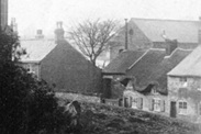
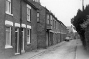 The bottom end of Park Road is the only unadopted section of road remaining in the village. This road is an excellent example of how Anstey looked at the end of the 19th century with a cobbled pavement and mixture of houses. The road would have been central to village life as it had manufacturing and services as well as domestic dwellings.
At the entrance of Park Road, with No. 2 on your left-hand side, you can see the remains of the ‘outside water closets’ on the left- hand side.
The road would have originally continued to Anstey Mill and was called Mill Lane.
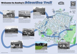
 The most prominent building on the corner of Park Road and Bradgate Road, is the first official village school, Bradgate Road Board School, which came into being as a result of the 1870 Education Act.
This made provision for all children aged 5 to 13 years.
This act was very divisive in the village but after some opposition it was agreed to build a school.
The land was given by Samuel Burchnall and village people helped build it with local materials.
It was opened in March 1874 to replace the National School in Church Lane.
The first headmaster and school teacher were Mr Albion Chard and his sister Emma Chard. Albion Street was later named after Mr Chard.
The school was organised into three classes.
This was not necessarily by age, as at this time children frequently needed to reach a certain standard before they were allowed to go into the next class.
When Latimer Street School was built the board school became the village infants’ school. The school on Park Road finally closed in 1982, when the remaining children were transferred to the Latimer School.
The site has now been converted to housing.
Walk to Bradgate Road. Cross over and follow the road downhill, around the bend. When you reach The Jetty on the right, go through into Latimer Street.
 Although relatively small, Latimer Street has played an important part in Anstey’s history. The Victorian terraced houses were built as the shoe trade expanded.
Many of Anstey shoe factories traded from this street at some time in their history as did other associated businesses such as box factories.
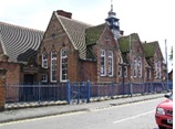
The Latimer School occupies much of one side of the road.
This ‘new’ five room school was opened in January 1896 as an extension of the Bradgate Road School to help with overcrowding. Mr John Bassett was its first Headteacher.
It was transferred from the school board to Leicestershire Council in 1903.
In 1912 the Anstey Council Junior School was built on the other side of the jitty as the school was still too small and classes were being held in the Methodist school rooms on Cropston Road.
In 1928 Latimer became an elementary school.
The infant school remained on Bradgate Road, the older children transferring to Latimer where they took the 11+ exam. Those who passed went on to an appropriate grammar school, either in Loughborough or Quorn. Those who failed, remained at Latimer Street in the 1912 building which was named the Senior School. The infant and junior schools were combined in 1967, by which time the Martin School had opened in 1956 as a high school, on Link Road.
Note the separate entrances for girls and boys and the bell tower.
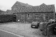
 The building half way down the jitty, between the two buildings, on the right-hand side, was originally used for woodworking classes for boys and cookery classes for girls. It also housed the tools for the gardening classes which the boys attended.
These classes ceased when Anstey Martin School opened and later it became Anstey’s library.
Follow Latimer Street to Leicester Road and cross over at the traffic lights. You have reached The Nook which is now the main focus of the village.
 The Nook, originally, joined Anstey’s two main roads – Main Street (now Bradgate Road) and Cropstone Road (now Cropston Road).
The 1761 Enclosure Map of Anstey shows a small structure marked in the centre of the Nook, where the roundabout is today, labelled ‘Stamford’. There is no record of what this building was, but speculation is that it could have been a market hall, cheese market or village hall.
Most probably it was a lock up, somewhere to hold people until they were able to be removed to a court or to hold drunks overnight until they were released next day.
The Earl of Stamford was a major landowner in the area at this time.
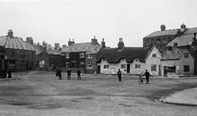 Until the 1920s The Nook was a wide-open space, surrounded by cottages and shops, often used as a playground for the children of the village. Over the years it has replaced Main Street (Bradgate Road) as the focus of the village.
The early buildings around The Nook were cottages, many of them thatched. A number of these were built with steps to prevent them being flooded. These later became shops in the early 20th century and most of the shop keepers lived over the premises.
As there was no decent road into Anstey from Leicester and surrounding areas until the 20th century, most shopping was done locally. This resulted in a vast array of shops, ranging from food to clothes. Much of the produce was supplied locally which accounts for the large number of farms, bakers, butchers and dairies being recorded.
Most of these buildings have now disappeared, but the café on the corner of Cropston Road gives an indication of how the original buildings would have looked. Even though some shop fronts have changed, the roof line of many of these premises remain.
 The Methodist Church, on the right – hand side of Cropston Road, was originally the Methodist Sunday School building. Tthe foundation stones were laid on 25th June 1892 by members of the Primitive Methodist Church, most of whom were prominent Anstey citizens.
It was this building that was used as an extension of Latimer Street School prior to the 1912 extension.
Three classrooms were established and The Nook was used as the school playground.
Continue walking along Cropston Road, until you reach Albion Street on the left - hand side.
 The lower part of Albion Street is another Victorian street with a mixture of terraced houses and villas.
It was named after Albion Chard, the first headmaster of the Anstey Board School on Park Road, who was also the secretary of the Land Society on which the road stands.
Originally the road only went as far as Andrew Road until it was extended to its present length by demolishing some of the houses in the then named High Street. This can be seen by the gaps in the present Andrew Road house numbers.
This new section was called Albion Road for a while, before the whole length was named Albion Street.
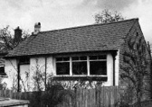 When Albion Chard died in 1885 his wife Julia, three children and sister Emma moved to 16 Albion Street.
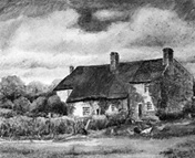
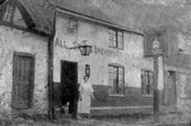
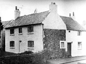
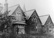
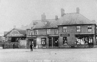
In 1890, Julia Chard opened a private school at the back of the house.
She was known as Widow Chard and children paid 1shilling a week to attend, so only the rich would have been able to afford the fees.
The school, as shown in the image, closed around 1904. The old building no longer exists.
You now have 2 options. You can finish the trail of Education in Anstey at this point or you can continue to the three latest schools in Anstey and bring the story up to date. To continue, follow Cropston Road until you reach The Anstey Nomad Football Ground.
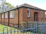
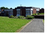
Wolfdale School is situated in the grounds of Anstey Nomads Football Club.
This is an independent special school, founded in 2016.
It caters for children aged 7 – 16 years old who have found main stream schools challenging.
Follow Cropston Road until you reach Link Road. Turn left, walk on the right-hand pavement until you reach Netherfield Road, on you right. Turn in to Netherfield Road and walk a little way until you reach Woolden Hill School on the right.
 By the 1970s Anstey’s population had increased significantly and Latimer School had approximately 700 on its register.
The decision was made to build a new primary school to cater for those children who lived on the other side of the village to Latimer Street.
Woolden Hill Primary School opened in September 1977. The first headteacher was Miss Pat Wells.
Some of the Latimer School staff transferred to the new school.
It was built as an open plan school with a nursery unit, although it is only recently that a nursery has been established.
Return to Link Road, turn right and follow the road up the hill until you reach The Martin High School on the right.
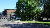 The Martin High School, named after the Martin family, was opened in 1956 as a Secondary Modern School, to cater for those children who had failed to obtain a place at a grammar school and to free up space at Latimer Street School.
The first Head Teacher was Ken Mayes.
In 1967 it was reorganised as a Leicestershire High School for 11- to 14-year-olds when the 11+ exam was abolished with pupils transferring to either Longslade School (now The Cedars) in Birstall or Rawlings School in Quorn until they reached 16.
In 2017 the school became part of The Lionheart Academy and pupils now remain at Anstey Martin until they are 16 years old.
You have completed the Anstey Education Trail
Time: Approx. 45mins or 1 hour for the extension