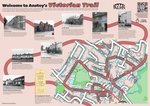
Victorian Anstey Trail
Introduction to Victorian Anstey
The Victorian Age was the period of most change in Anstey.
Anstey had developed around two nuclei: one around the Top Green and the other around St Mary’s Church. The development later continued around The Nook.
By the beginning of the 20th century, it was a large village and a centre of the boot and shoe manufacturing.
All three areas were joined by Main Road (now Bradgate Road), which had always been the connexion between the three nuclei, now became the main focus and it was here that the village services were found. Public Houses, brewery, bakers, a slaughter house, butchers, school, chapels, shops to name but a few.
From about 1850 the stocking trade had declined in the village as the rise in factory-made stockings meant that the cottage industry was no longer viable.
The villagers transferred their skills to the new boot and shoe manufacturing and although most of the work was done in factories, the ‘finishing’ was often carried out in back yard workshops.
New terraced houses were built by the factory owners, in particular George Palmer, to house their workforce.
Between 1860 and 1900 Anstey’s population soared from 768 to 2,544 due to these industries.
As well as the factories, other associated industries were needed such as box factories and haulage; examples of which were established in Anstey. In the 1895 Trade Directory 23 shoe factories were recorded.
Land Societies, known as Lannys, were formed as a way to acquire land on which people, who were attracted to the village by the new shoe factories and other industries, could build their own houses after obtaining mortgages from the newly established building societies. As property owners, these people also gained the right to vote.
People paid weekly, monthly or in one lump sum for one or more allotments which could then be used for building. Anstey had three such societies.
A number of the new shoe manufacturers used this system to build houses and some, such as Thomas Graves, George Jackson and Thomas Pickett built a shoe factory in Gladstone Street.
Many of these houses were given names, significant to the builder.
As there was no main road in or out of the village, Anstey was almost self-sufficient.
The numerous farms produced milk, meat, which was slaughtered in the village and even cheese; the bakers provided the bread. Butchers, a miller, a wheelwright, were among people who also served the village.
In the 1867 Trade Directory there were joiners, tailors & drapers, a timber dealer, bakers, shopkeepers, blacksmith, a brewery as well as farmers.
Between 1855 and 1861, William Moore was employed as the receiver and postman for the village and by 1877 Anstey had its own postmistress.
The growing population meant that other facilities were needed and during this period the 1870 Education Act resulted in a new board school.
Three non- conformist churches, to accommodate the large non- conformist population were built.
The Congregational Church and Wesleyan Chapel on Main Street (Bradgate Road) and the Primitive Methodist Church and Sunday School on Cropston Road.
As the 19th century drew to a close, The Nook began to expand and the number of shops and services there increased.
The services on Bradgate Road and The Nook can be explored in the Occupations, Trades and Shops Trail.
It is your responsibility to be aware of whether you are allowed to access any area, to follow the Highway Code, and to be observant of any hazards which may be present along or near your route.
If you experience any issues while following the trail please Contact Us and provide a description.
We hope you enjoy the trail and we would really appreciate your feedback.
Map showing Start of Trail
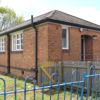
The board for this trail is installed on Park Road, opposite the Old Schoolhouse.
Map view of the Victorian Anstey Trail starting point
Street view of the Victorian Anstey Trail
Clicking the links will either open a new tab on your browser or the Google Maps app
New Feature: You can now click on any of the images for this trail to view a full sized photograph on screen in a lightbox, and click again to close it.
Begin the Trail at Park Road and walk to the end of the road
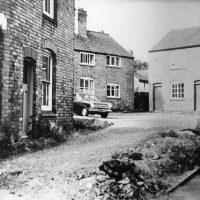
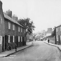
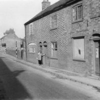
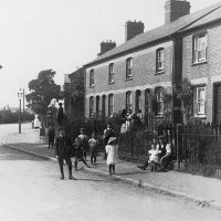
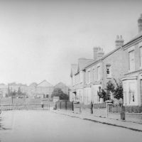
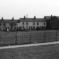
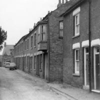 The bottom end of Park Road is the only unadopted section of road remaining in the village. This road is an excellent example of how Anstey looked at the end of the 19th century with a cobbled pavement and mixture of houses. The road would have been central to village life as it had manufacturing and services as well as domestic dwellings.
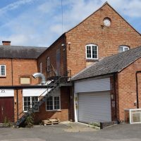
The road would have originally continued to Anstey Mill and was called Mill Lane.
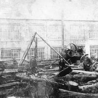
It was here that a factory was built which became home to numerous shoe companies.
 G.H. Palmer began his career as a shoe manufacturer working at this factory, followed by Job and William Wright who carried on trading as C. Pollard & Co.
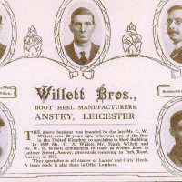
Next were Smart, Cufflin and Co, Abraham Willet and his son, John Walter and finally Willett Bros. Heel Factory.
Behind the factory was the bakery run by ‘Doughy Harris’, who had a shop at the bottom end of Bradgate Road.
The site is now a private house named The Bakehouse.
Turn and walk back towards Bradgate Road
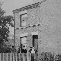
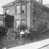
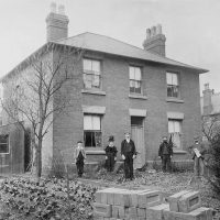 No 3, Park Road, Mafeking House, on your left, was built by George Lowe, a hosiery manufacturer, in 1874.
The knitting frame industry was the main industry in Anstey during the 18th and early 19th century and almost all villagers, including children, would have been employed in some way.
The property had a large brick building behind it known as The Shop. This housed up to 8 knitting frames, of which two were still used up to WW1. The stockings were sold in Leicester.
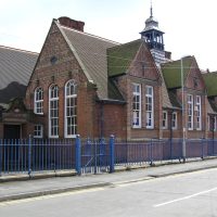
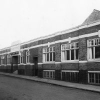
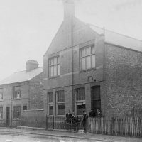
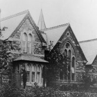 The most prominent building is the Board school. This was opened in March 1874 to replace the National School in Church Lane.
The first headmaster and school teacher were Mr Albion Chard and his sister Emma Chard. Albion Street was later named after Mr Chard.
The school was built from local materials with the help of local people after a suitable site was found.
When Latimer Street School was built it became the village infants’ school and finally closed in 1982 when all children were transferred to the Latimer School. By this time Woolden Hill School had opened to accommodate the children on the other side of the village.
The site has now been converted to homes.
At the entrance of Park Road, with no 2 on your left-hand side, you will see
the remains of the ‘outside water closets’ on the right- hand side.
Cross over Bradgate Road, turn left and then turn right into Church Lane. Bradgate Road can be investigated in the Trades, Occupations and Shops Trail
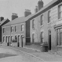
 Church Lane, another of the ancient roads in Anstey is situated next to the church and was part of the Medieval centre of the village.
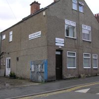
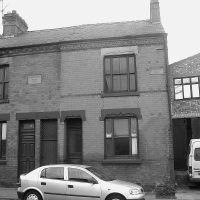
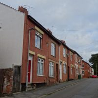
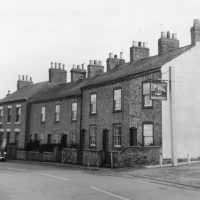
Most of the surviving houses in Church Lane were built in the late 19th or early 20th century for the growing population of workers in the village boot and shoe industries. There were alleys and yards leading off with names such as Kidney Bean Alley, Wells Yard and Clarkes Yard as well as Papermill Row. A large number of these houses have now been replaced with modern builds. However, enough remain to give an idea of what the area would have been like. The numbering of the houses indicates how many of the original have disappeared.
At the Bradgate end of the road, near the site of The Plough Inn which is the grey, square building, on the left- hand corner was another of Anstey’s many shoe factories.
This was built by Henry Clarke, behind to his Georgian House. He was responsible for building many of the houses in this area.
Unfortunately, the factory burnt down in the early 20th century when it was occupied by ‘The New Firm’, which was an early example of a co-operative.
Follow the road forward past a terrace of Victorian shoe workers cottages.
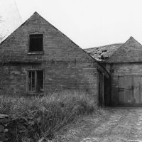
The building on the corner of Caters Close, was built about 1830 to replace the yeoman’s timber- framed farmstead that stood on the site next to it. Note the brickwork on the former stables.
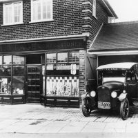
The garage, next to the Victorian terrace, was built around 1906 by Maurice Reeson to house his horse drawn coach and later his motor bus ‘John Bull’. This was one of the first motorised buses in Leicestershire. This business was taken over in 1911 by Johnny Hutton who garaged his coaches and delivery vans on this site for many years.
The building next door to the terraced houses was the village Adult School.
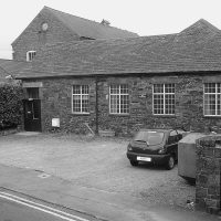
This building has had a long and varied life. It was built in the mid-19th century and was used as a papermill around 1875 –1887, hence ‘Papermill Row’ behind where the library is now. It then became a boot and shoe factory; followed by the Adult School & Institute for many years.
Next is St Mary’s Church Rooms.
Built as the schoolrooms of St. Mary’s Church in 1833, the building was the first purpose-built establishment for education of children in the village. Following the Elementary Education act of 1870, the Bradgate Road board school was built in 1872 and after a bitter struggle against “the Godless School” as the new school was known, St. Mary’s school closed in 1880.
The house opposite the Church Rooms was where the curate, who assisted the rector lived. This meant that he was near to the church. Originally a door would have led straight onto the churchyard. Although this is now blocked up, the outline can still be seen.
Continue to walk down the road, passing St Mary’s Church, which was rebuilt in 1846.
There is a separate trail for the church and churchyard.
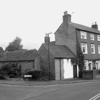 Follow the road forward past a terrace of Victorian shoe workers cottages.
The building on the corner of Caters Close, was built about 1830 to replace the yeoman’s timber- framed farmstead that stood on the site next to it. Note the brickwork on the former stables.
 The garage, next to the Victorian terrace, was built around 1906 by Maurice Reeson to house his horse drawn coach and later his motor bus ‘John Bull’. This was one of the first motorised buses in Leicestershire. This business was taken over in 1911 by Johnny Hutton who garaged his coaches and delivery vans on this site for many years.
 The building next door to the terraced houses was the village Adult School.
This building has had a long and varied life. It was built in the mid-19th century and was used as a papermill around 1875 –1887, hence ‘Papermill Row’ behind where the library is now. It then became a boot and shoe factory; followed by the Adult School & Institute for many years.
 Next is St Mary’s Church Rooms.
Built as the schoolrooms of St. Mary’s Church in 1833, the building was the first purpose-built establishment for education of children in the village. Following the Elementary Education act of 1870, the Bradgate Road board school was built in 1872 and after a bitter struggle against “the Godless School” as the new school was known, St. Mary’s school closed in 1880.
 The house opposite the Church Rooms was where the curate, who assisted the rector lived. This meant that he was near to the church. Originally a door would have led straight onto the churchyard. Although this is now blocked up, the outline can still be seen.
Continue to walk down the road, passing St Mary’s Church, which was rebuilt in 1846.
There is a separate trail for the church and churchyard.
At the bottom of the road, cross at the traffic lights and follow The Jetty to Latimer Street
 Although relatively small, Latimer Street has been an important part of Anstey’s history. The Victorian terraced houses were built as the shoe trade expanded.
Many of Anstey shoe factories traded from this street at some time in their history as did other associated businesses such as box factories.
The original company to occupy the premises on the right -hand side of the Jetty was J. Wright and Co.
Founded around 1905 by Job Wright, it was one of the earliest box factories in Anstey.
It later became Pollard Boxes which traded until the 1990s.
 On the other side of the Jetty, between Bradgate Road and Latimer Street, J. and J. Springthorpe’s Boot and Shoe works was established in May 1910.
The business was established by James Springthorpe, who had 30 years’ experience in the trade and his son John, who had previously worked for the ill-fated shoe cooperative in Church Lane.
Walk down Latimer Street towards Leicester Road
 On the right- hand side, behind the building that now houses Anstey Vets was Smith Boot Manufacturer. This was established in 1913 by J.A. Crooks, T. Smith, G. Griffin and A Moore and produced hard wearing boys’ and girls’ boots, both for wholesale and retail. By 1917 a new wing and storage area for leather had been added to the original premises.
 On the opposite side of the road, where the new (2025) flats are situated, was a factory that became the premises of a number of Anstey Shoe companies.
The first was Willet Bros. Heel Factory.
Established in 1899 by three brothers, Charlie, Frank and Will Willett, it carried on business here until 1912 when the family moved the business to Park Road.
The next business to use the premises, Gelsthopes, was established by S.A. Gelsthorpe with Alec Bramley as manager. Both men originally worked for Graves, Jackson, Richards and Co. in Gladstone Street.
This was followed by Pollard and Wain, established in the early 1900’s. As a result of growing demand, the company needed to find larger premises and later moved to a purpose-built factory which stretched between High Street (now Andrew Road) and Roseberry Road.
The final company to occupy the premises was Kenilworth Box which traded until it closed in 2006.
Retrace your steps
 The Latimer School occupies much of one side of the road.
This new five room school was opened in January 1896 as an extension of the Bradgate Road school to help with overcrowding. It was transferred from the school board to Leicestershire Council in 1903.
In 1912 the Anstey Council Junior School was built, as the school was still too small and classes were being held in the Methodist school rooms on Cropston Road.
The two schools amalgamated in1928 to form an elementary school
The infant school remained on Bradgate Road.; the older children transferring to Latimer and to take the 11+ exam. Those who passed went on to the appropriate Grammar School; those who failed remained at Latimer Street in the 1912 building’ which was named the Senior School.
The infant and junior schools were combined in 1967, by which time the Martin High School had opened in 1956.
Note the separate entrances for girls and boys and the bell tower.
 The building half way down the jitty, on the right-hand side, was originally used for woodworking classes for boys and cookery classes for girls.
It also housed the tools for the gardening classes which the boys attended.
These classes ceased when the Martin School opened and later it became Anstey library.
Follow the jitty between the 2 school sites to reach the Bottom Green.
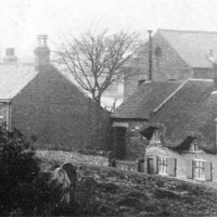
 The Lower or Bottom Green is one of Anstey’s two ‘Greens’.
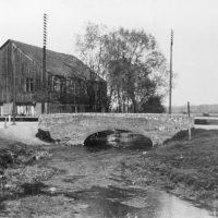
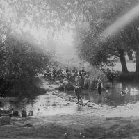
The Anstey (Rothley)Brook runs through here and there are two bridges to be seen.
The main road bridge is the third bridge built in this position. The first was a stone bridge built to replace a ford. When this bridge was badly damaged in 1924 by a Great Central Railway lorry it was replaced with a concrete structure. In 1995 it was upgraded to meet European standards.
Next to it, is a gas pipe laid down in 1895 when gas was brought to the village.
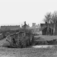 The other bridge spanning the brook is the Packhorse Bridge, which is one of two such bridges that are found in Anstey.
It is one of the oldest structures in the village and believed to date from around 1500, although the track itself is probably much earlier.
It is one of the best-preserved packhorse bridges in Britain. Note the V shaped features which enabled people to move out of the way of the laden horses as they passed. Hence its name.
Looking towards the village, next to the jitty, there was originally a wooden hut belonging to the Parish Council. It was at one time home to the hand – propelled parish fire appliance and horse drawn funeral hearse. The fire station later relocating to Rosebery Road.
Walk in front of the row of houses facing the brook until you reach the main road.
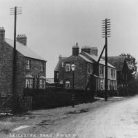 Leicester Road has always been a direct way into Anstey from Leicester, even though it was not metalled until 1923.
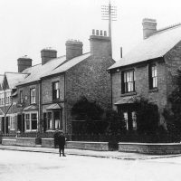
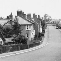
The houses facing The Green and those around the corner on Leicester Road were built at the end of the 19th century to house the expanding village population and are traditional Victorian brick-built terraced houses with slate roofs.
On the right-hand side of the road, the building that now houses Potters Carpets, has been an integral part of the life of Anstey for over 100 years.
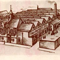 Originally this was known as the Bridge Works. In 1906 Thomas Pickett moved the shoe company that he founded in the 1880’s, in Latimer Street, to this site and by 1917 it was producing 3,000 to 4,000 pairs of shoes a week.
The company moved out in the early part of the 1930’s
Opposite, the building, now Anstey Funeral Directors, has been the premises of a number of factories important in the development of the village boot and shoe industry.
The first company to use the building was Springthorpe, Black and Hunt.
This was one of the oldest shoe businesses in Anstey, being established in 1882. The original business carried on business until 1889 when it was dissolved and became Springthorpe, Hunt and Company.
The company was wound up in 1926 during the General Strike.
 Number 7 Leicester Road was the original Anstey telephone exchange until the new exchange was built on The Green. Note the bracket, just to the left of the door that held the Telephone Exchange sign
The one exception in this row of terraced Victorian houses is No 1a, a villa, built in 1884, as the home of Mr Ernest Bosworth, who was the Anstey Parish Council secretary, rate collector and registrar from 1914 to 1947.
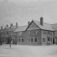 On the opposite corner stands The Coach and Horses Public House, built in its present form around 1895 when the business was taken over by Marstons Brewery and the much earlier building, predating the 1841 census was demolished.
Part of the car park was originally the stables for the horses.
You have reached The Nook which is now the main focus of the village.
 The Nook, originally, joined Anstey’s two main roads – Main Street (now Bradgate Road) and Cropstone Road (now Cropston Road).
hall.
The 1761 enclosure map of Anstey shows a small structure marked in the centre of the Nook where the roundabout is today and labelled “Stamford”. There is no record of what this building was, but speculation is that it could have been a market hall or cheese market.
More probably is that it was a lock up; somewhere to hold people until they were able to be removed to a court or to hold drunks overnight until they were released next day.
The Earl of Stamford was a major landowner in the area at this time.
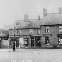
Until the 1920’s The Nook was a wide-open space, surrounded by cottages and shops, often used as a playground for the children of the village. Over the years it has replaced Main Street (Bradgate Road) as the focus of the village.
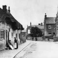
 The early buildings around The Nook were cottages, many of them thatched. A number of these were built with steps to prevent them being flooded. These later became shops in the early 20th century with most of the shop keepers living over the premises.
As there was no decent road into Anstey until the 20th century, most shopping was done locally. This meant there was a vast array of shops, from food to clothes. Much of the produce was supplied locally which accounts for the large number of farms, bakers, butchers, dairies recorded.
Most of these buildings have now disappeared, but the café on the corner of Cropston Road gives an indication of how the original buildings would have looked. Even though some shop fronts have changed, the roof line of many of these premises remain.
Go into the car park which is on the far side of The Nook
 Part of the village car park was originally an area of houses known as Nook Yard. A number of these houses were converted in Victorian times from cruck frame cottages. The stump on the left-hand side, near the 1st parking sign, is all that remains of them.
J. Gray lived in the family house no 25 The Nook and carried on business behind the house in Nook Yard. This was advertised on the house wall as; wheelwright, carpenter, painter, undertaker. The company remained until 1966.
Leave The Nook, turning left to follow Cropston Road
 Cropston Road was another main route into Anstey; from Cropston and was originally known as Cropstone Lane; later Cropstone Road. The spelling being changed in the early 20th century.
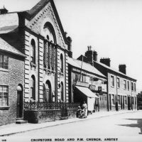 The Chinese Takeaway is on the site of Anstey Methodist Church, which served the Primitive Methodist movement. The church was built in 1870 to replace the earlier 1840 building and was extended in 1872 using bricks made at Whitwick Colliery. Services continued until 1970 when worship was stopped due to the poor condition of the building and it was demolished in 1973.
The Methodist congregation, subsequently, held their services in St Mary’s Church until 1988 when the Sunday School building opposite was converted to a place of worship. The foundation stones for this building were laid on 25th June 1892 by members of the Methodist Church, most of whom were prominent Anstey citizens.
Next door to the Chinese takeaway is the entrance that led to Norwood Press Printers which was located in the building behind until 2007.
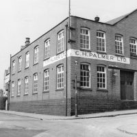
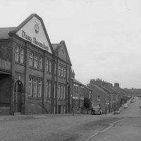
This building was built around 1885 for the Leicester manufacturer, George Green and Sons, who moved his boot and shoe factory to Anstey to make use of the lower rates in the village. By 1920 it was occupied by another shoe manufacturer, C.H. Preston
 The last Shoe manufacturer to occupy the building was Burton and Stone, who moved in after the war. The company had been founded in 1925 by Fred Burton and traded until 1977 when it became the final Anstey shoe factory to close, bringing to an end approx.125 years of shoe and boot manufacturing in the village.
The building is now divided into small units.
Numbers 10 to 18 Cropston Road, were built in 1899 and named Amphora Cottages. It is said that they were built from the proceeds of a win on a horserace by a horse named Amphora.
 The next group of buildings, now a gated residential complex, was one of Anstey’s many farms, Elms Farm.
Sam Burchnall, a major landowner in the village, first moved into the 17th century farmhouse, while the adjacent farmhouse, which appears in the Rate Books for the first time in 1834 was being built. The property remained in the family until the death of last inhabitant, when the house and all of the outbuildings were sold. It was subsequently restored and developed in 2004
The 17th century farmhouse became known as the “Mews”. There is evidence of the roof being raised to provide an upper floor, together with the period diaper brickwork and the bricked-in window which was probably the result of avoiding the “window tax” imposed by King William III in 1696. A tax that gave rise to the phrase ‘daylight robbery’.
 The buildings both sides of the Co-op site would have been cottages; one of which, owned by Jack Smith is known to be one of the last framed knitting cottages in the village and had the characteristic long windows which allowed optimum light to enter.
The terraced Gladstone Cottages would have originally continued at a right angle. One of the now demolished houses is said to have been be the site of an Anstey poor house
Although records show that Anstey had a workhouse and a number of poor houses, there is no definite evidence to where these may have been.
Continue past the bungalows on the left-hand side, originally allotments known as Beancroft, noticing the housing estate on the right
 This is built on the site of Melody Mills Wallpaper Factory; notice the street names. The factory was previously Marwins Engineering.
Stop when you reach no 56, Holly House.
Holly House was built in 1885 for William Hughes Richards and his wife Sarah, when they got married, with two shares in the Land Society – known locally as “Bottom Lanny”. William Hughes Richards was a member of one the families who founded Graves, Jackson, Richard and Co shoe factory, which was nearby in Gladstone Street.
The Land Societies, known as Lannys, were formed as a way to acquire land on which people, who were attracted to the village by the new shoe factories and other industries, could build their own houses after obtaining mortgages from the newly established building societies. As property owners, these people also gained the right to vote.
These people paid weekly, monthly or in one lump sum for one or more allotments which could then be used for a building.
Anstey had 3 such societies:
• Working Men’s Club Land Society (1879) “Bottom Lanny”; Albion Street, Andrew Road (High Street), part of Gladstone Street and part of Cropston Road.
• Forest Gate Land Society (1891) “Top Lanny”; Forest Gate, Hollow Road, Ellis Road (now Street)
• Prudential Land Society (1897) “Klondyke”; Upper Edward Street, upper Albion Street, Dalby Road, Kitchener Road and Rosebery Road.
 On the other side of the road is Broughton’s Ironmongery Shop.
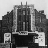
This is the site of The Savoy Cinema, one of two cinemas in Anstey.
It was originally called The Coronet and the building of the Cinema was completed in 1937; the year of the coronation of King George VI and Queen Elizabeth.
By 1950 the Coronet Cinema had been renamed the Savoy Cinema.
It finally closed in the 1960’s and was converted into use as a garage and filling station which closed in 1988.
 The Signal Box on the corner of Albion Street, was established in the 1980’s in a shop that was built in 1890 and until that time had always been an off licence. A blocked-up door and windows can be seen.
The house next door was Storer’s Shop, run by Tommy Storer and well known for its ice cream, produced from a secret family recipe.
 The road continues past a series of terraced houses. The block (just past Gladstone Street) was the end of the village.
 The backs of Hope Cottages which are on the left-hand side at the bottom of the road, show the remains of outside water closets and garden plots separated from the houses by a communal path; hardly unchanged since they were built.
 Opposite Hope Cottages was ‘Plum Ford’.
One of the meanders of the Anstey brook came right up to the road at this point and for decades it was a popular crossing point for the villagers and a playground for children. The brook was realigned in the early 1960’s to help prevent flooding and the site is now used as a garage.
Return to Albion Street
 The lower part of Albion Street is another Victorian street with a mixture of terraced houses and villas.
It was named after Albion Chard, the first headmaster of the Anstey Board School on Park Road, who was also the secretary of the Land Society on which the road stands. At the rear of no 16 was the private school which was set up in 1890 by his widow.
Originally the road only went as far as Andrew Road until it was extended to its present length by demolishing some of the houses in the then named High Street. This can be seen by the gaps in the present Andrew Road house numbers.
This new section was called Albion Road for a while, before the whole length was named Albion Street.
Continue up Albion Street, crossing Andrew Road (High Street).
 The corner of Albion Street and Rosebery Road was the site of Broughton’s Timber Yard, another of Anstey’s long-standing businesses. The company began business on Bradgate Road in the early 20th century before moving to Rosebery Road.
In the late 1940’s the company relocated to Upper Edward Street (near its Link Road end), where it remained until it closed down and Broughton Close was built on the land.
 Look to the right down Rosebery Road. The housing development is built on the site of Pollard and Wain Shoe Company which was first established in Latimer Street at the beginning of the 20th century. Growing demand resulted in a move to a purpose built and well fitted factory which covered an area from Andrew Road to Rosebery Road.
The company specialised in the manufacture of high-class boys and girls boots and shoes and was one of the successful Anstey shoe companies, becoming known as the national firm Airborne Shoes.
 Near to the junction with Edward Street stands the building that was Pages Bakery. The bakery had been established in 1880 by Tom and Walter Page in Main Street (now Bradgate Road). Walter ran the bakery near to the Park Road School on Bradgate Road, which will be visited later and later Tom ran this shop. The building at the rear is now a community pub.
Turn left along Edward Street and then left again down George Street into Highfield Street and then turn right towards the village centre.
 This area, known as New Anstey, was built as housing for the expanding shoe and boot workers. Most of these workers were employed by George Harry Palmer in his factory at the bottom of Highfield Street.
Turn right onto Stadon Road.
 Known as Stadon Lane in the 1761 Enclosure Award, the name had disappeared by 1895 when it became Throne Lane. It ran from the Nook to a point approx. opposite the Working Men’s Club (now Sapori, an Italian restaurant), then turning right past the end of George Street.
Originally a cul de sac, the road stopped just by the Recreation Ground. Colonel R.F. Martin, who owned the land, built a link road through to Hollow Road/ Ellis Street junction, but because of a dispute with the Parish Council over its upkeep, it was fenced off at either end for a considerable time.
As you walk up the road, notice that the buildings at The Nook end were built as terraced houses and cottages, many of them becoming shops, whereas the houses further up were built for more affluent people.
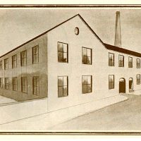
 The Mill Court Development, on the corner of Highfield Street, is built on the site of one of Anstey’s best-known companies.
Begun in 1890 by G.H. Palmer in Church Lane, the company soon moved to Main Street (Bradgate Road) to what is now the Stadon Club.
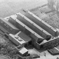
In 1892 it moved again; this time to new premises in Stadon Road and over the years was extended. By 1917 it was regarded as one of the best equipped shoe factories in Leicestershire, producing ladies, girls’ and boys’ shoes, for both the home market and export.
In later years it traded as “Eagle Shoes” under George White.
 On the left-hand side of the road is the Italian restaurant, Sapori, which was formally Anstey Working Men’s Club. The first club house was founded around the 1880s.
 As you proceed up Stadon Road the houses become more imposing. These were built by prominent local business men for their families.
‘The Hollies’, on the left-hand side, was built by the aforementioned George Harry Palmer, as he wanted to live close to his new factory so he could keep an eye on what was going on, at all times.
The 1970’s houses, on the right, are built where Palmer’s tennis courts once stood. Those on the left are built on part of the garden belonging to ‘The Hollies’.
 The library and housing complex were built in the 1970s on the site of a row of terraced house known as Poplar Terrace or Papermill Row.
These cottages made up one of the ‘yards’ off Church Lane and was connected to Church Lane by the lane running down the side of the building which housed the Adult School. Although named Poplar Terrace on contemporary maps, it was numbered, from 1923 when house numbers began, as Church Lane.
This meant that the people who lived there actually had 3 different addresses for the same house.
 The large field at the top of Stadon Road is known by all Anstey folk as The Reccy.
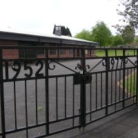
Villagers fought for many years to have a recreation ground in the village. Even though the subject was mentioned in Parish Council documents as far back as 1928, it was not until1952 that land was purchased for this purpose. It cost the parish £1,400 which included piping the ditch that had run across the field for many years and levelling out the ridge and furrows.
The new Jubilee Hall was built in 2003 to replace the original Memorial Hall, which had stood on the same site.
The gates were erected in 1977 to celebrate the Silver Jubilee of Queen Elizabeth II.
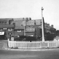
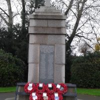 In 1919, the Parish Council discussed three alternatives for a memorial to those who had lost their life in WW1; public baths, a village hall or a memorial in The Nook.
In the end Anstey War Memorial was erected on land given by The Martin Family.
It was built using Mountsorrel granite and Swithland slate and was dedicated on 7th May 1921.
At the end of WWII, 25 names were added to the 113 already on the memorial.
Continue to the top of Stadon Road. This the Junction with Hollow Road and Ellis Street
 The short street in front of you was known as Martin Ellis Street until 1899 when the Martin name was dropped. The Martin’s were wealthy landowners; the Ellis’s were not only wealthy, but were also Liberal, as were the majority of Anstey at the time. This could be the reason for the name change.
Hollow Road was originally a cul de sac named Hollow Lane, which led from The Green to a point just past the Stadon Road junction. The top end of the road was a fenced off field with a pond and a large Elm tree until the council houses were built in the 1950’s
The top end of the road is mostly terraced houses built for shoe workers. The remainder of the road consists of villas and larger houses built by wealthy factory owners for their families, many as a result of the Land Lannys.
 The Shoemakers housing development, on the right, was built as a shoe factory in 1895 by Cornelius Smith, in partnership with John T Brammage. Smith lived next door at no 40 which was the house he had built at the same time as the factory.
By 1915 the company was run by William Mason and was renamed Diana Shoes, which became a well-known British shoe brand until it ceased trading in the 1970’s.
 Bosworth and Wright Box Factory, further down the road, was founded in the 1920’s by Arch Bosworth and Ernest Wright.
This new ‘Express factory’, was built around 1934 and remained as a box factory until it closed in 2025, being the last of the factories related to the shoe trade to cease trading.
Continuing towards the Green, passing the present-day bungalows, on the right, which were originally thatched cottages. It was from behind these that a dyke ran from the Top Green, under the road and down through the Recreation Ground to the Brook.
At the end of Hollow Road, you reach The Top Green
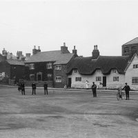
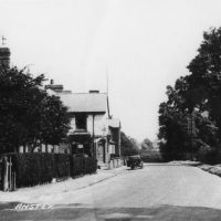
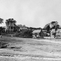 This area is the second of Anstey’s two ‘greens.’ Known as The Green or The Top Green, it was one of the main parts of the village.
The area was mentioned on the Enclosure Map of 1761 when it was common land known.
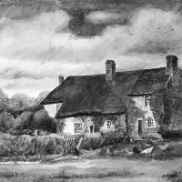
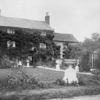
Originally very rural, The Green was surrounded by farms and cottages; some thatched and some slated; some dating to the 15th Century. The large Georgian House in front of you being an exception.
 On the left corner of Hollow Road there was a cottage where a Mrs Levis ran a Dame School. One of the first educational establishments in Anstey. It was a forerunner of an organised education system for the village children.
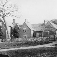 Green Farm (to the right of the Georgian house) is said to be the oldest domestic building in the village and parts of it have been shown to date to the 15th century. The more modern house adjoining it was built about 1800.
The farm originally belonged to the Martin Family and then by subsequent families until farming ceased in 2002.
The white building at the far side of the Green, Manor Farm, belonged to Ulverscroft Abbey until the land was possibly allotted to the 7th Earl of Stamford (Grey Family of Bradgate) as a result of the Enclosure Award in 1762.
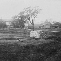 In the centre of the green is the village well. It is believed that the wall surrounding it is medieval.
Bradgate Road bisects the grass areas of The Green and continues towards Newtown Linford. Until 1950 part of this area was within the Newtown Linford Parish boundary.
 Situated up the hill toward Newtown Linford there are two houses of note.
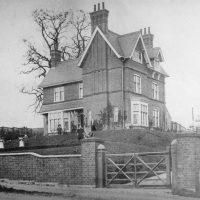
On the left-hand side stands the former rectory for St Mary’s Church, built in the early 1870s for the Rev Seldon, the first Rector of Anstey.
On the righthand side is a large detached house called ‘The Mount’, built by John Burchnall, the nephew of Samuel Burchnall.
You can make a detour to look at these
Follow the main Bradgate Road down the hill, past The Crown Public House on the right
 Originally named Main Street, Bradgate Road was the main street through the village, joining the now Cropston Road through the Nook and Newtown Lane towards Newtown Linford.
Until the latter part of the 19th century this area would have been fields and farms, interspersed with cottages.
It was from this main road that most of the village roads radiated when Anstey was a nucleus village and St Mary’s Church was the centre of the Medieval village.
It was the area where most of the population originally lived; the village only expanding with the coming of the boot and shoe industry in the 19th century.
A number of the original buildings remain, although most now have different uses with many being renovated for residential use.
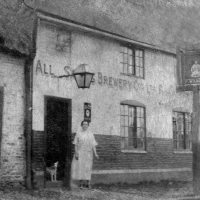 The Crown Inn on the right-hand side is one of the four main public houses in Anstey, that there were at one time probably run by Anstey’s Steam Brewery, before they were taken over by other breweries. It is said to be Anstey’s oldest public houses, possibly dating back to the 1700’s.
 Next to The Crown, were two rows of back-to-back houses,
with a shared row of earth closets. They were built by the Pettifor Family for their brewery workers and were known as Pett’s front and backs. These were demolished in the 1970’s and replaced with the modern houses you can see today.
The brewery, established in the 1840s, was built back from the road with cottages for the workers in front of it. It is now the site of Pettifor Court Retirement Complex on the left-hand side of the road.
 The house on the right-hand side, sideways to the road, is No 102, The Woodlands; built around 1800, it was a farmstead originally farmed by the Astill family.
Later it was owned by Daniel Pettifor of Anstey Brewery, becoming the home of his son Stanley, who was a dairy farmer. His ‘Woodlands Dairy’ was based at his farm; his cows being grazed at various points around the village. He delivered milk around the village until 1949 when Wilf Poole of Manor Farm took over delivering the village milk.
 Other buildings to note are No 84 which was the Smithy and No 60 which was the Slaughterhouse.
Most of the buildings on the left-hand side were cottages or shops.
One exception was the old Wesleyan Church, now a private residence. This building replaced an earlier chapel on Groby Road in 1895 and remained in use until 1940 when the church closed as a result of falling congregations and the union with the Primitive Methodist Church on Cropston Road.
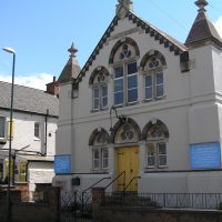 The United Reformed Church, originally known as Anstey Congregational Church, was formed in 1851 and for the first 3 years met in in a small cottage on the top Green, next to The Stew footpath (now marked as a public footpath next to The Crown), prior to the congregation moving to a barn on the corner of Groby Road.
In 1861 they purchased a factory owned by Mr S Lovett on Bradgate Road for £130 and converted it to a chapel. The present church was opened officially in 1879.
It closed in 2021 due to a dwindling congregation and it held its last service on Sunday 31st October 2021.
Further down, no 58 was Pages Bakery. This was owned by the Page Family. Walter ran the bakery on Bradgate Road and his brother Tom, ran the bakery in Albion Street. It had a shop at the front and a bakery and stables at the back.
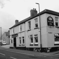 On the corner of Church Lane was The Plough Inn, which dates from the 1880’s and originally only served beer.
Till’s Butchers, another of Anstey’s 18th century farms, was converted to a butcher shop in 1896 to meet the needs of the expanding population.
Just before the church is no 53 Bradgate Road, at one time Anstey’s police house. In the 1890’s the village policeman who lived there with his family was James Johnson. He was the grandfather of the WWII flying ace Johnnie Johnson. When he died in 1904 his family continued to live in the village and a number of them are buried in Anstey Cemetery.
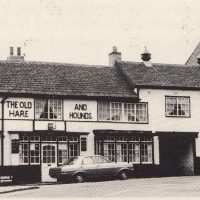 The Hare and Hounds, another of Anstey’s old public houses, pre dating the 1841 census.
Around 1843, it was the home of a female friendly society known as the United Shepherdesses. This was an insurance scheme, but with 35 rules for being allowed to join and receive benefits. Some of which were:
You had to under 35 years of age; you would not be accepted if you had had smallpox or cow pox; any member entering a workhouse or house of Industry would cease to pay and not receive anything from the society.
You have completed the Victorian Anstey Trail
Time: Approx. 1 hour 30 mins
If you want to explore St Mary’s Church and churchyard, please see separate trail