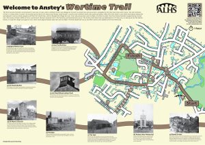
Wartime Trail
Introduction to Wartime Anstey
The earliest record of Anstey’s involvement in war was in 1430, when a person named William Porter, under the Feudal system, had an obligation to ‘furnish 19 armed men and 9 archers’. These men were probably required by Henry VI for the 100 Years War with France.
The next mention of war is in 1540, when a muster roll carried out by Henry VIII shows that Anstey could muster 7 archers and 13 billmen (men who could use pikes).
After this time, there is very little information about the part played in war by Anstey people until the First World War.
However, a document listing guests at an Old Anstey Reunion Dinner in 1909, gives the names of 52 men who had served their country and shows that medals were won in the Zulu, Afghan, Indian Mutiny, Boer and Crimean campaigns.
The First World War changed Anstey for ever. Over 400 young men went to fight, of whom 113 died. Very few Anstey families escaped losing a loved one.
The Anstey Citizens Defence Force (the forerunner of the Home Guard) was formed. They met in the ‘Tin Hut’ on the Upper Green. A shortage of weapons meant they had to train with broom handles.
Women replaced men in the factories and food became scarce.
Transport reverted to being either horse drawn or gas fuelled and it was a common sight to see buses with gas filled bags on their roofs.
Belgian refugees were housed in Anstey.
The local school teacher, Miss Grace Bickley, organised events and collections to raise money to buy sandbags to send to the trenches. A sandbag cost sixpence and the village raised 25 pounds and 2 shillings.
The Anstey War Memorial was dedicated on 7th May 1921, on land given by the Martin Family.
In 1939 the village was again at war. 500 men were involved and for the first time 30 women.
The final death toll was 21 and their names were added to the War Memorial.
The village adapted as they had in WWI. Dig For Britain, to help with food production and the Spitfire Fund to collect all types of metal were implemented.
German and Italian POWs were put to work on the village farms and evacuees arrived from Sheffield and London.
Perhaps most exciting for the children was that Bradgate Park became a training ground for soldiers and even though the whole area was out of bounds, some children managed to sneak into the park!
The nearest Anstey came to being bombed was in 1940, when a German plane returning from a raid on Coventry, dropped a bomb close to the path between Anstey and Cropston, just inside the perimeter of Fairhaven Farm.
The crater was filled in very quickly by the farmer as he said he didn’t want people coming onto his land to look at it!
The Wartime Trail visits some of the sites associated with these events, explaining the impact on Anstey and how the villagers adapted.
It is your responsibility to be aware of whether you are allowed to access any area, to follow the Highway Code, and to be observant of any hazards which may be present along or near your route.
If you experience any issues while following the trail please Contact Us and provide a description.
We hope you enjoy the trail and we would really appreciate your feedback.
Map showing Start of Trail
Map view of the Wartime Anstey Trail starting point
Street view of the Wartime Anstey Trail
Clicking the links will either open a new tab on your browser or the Google Maps app
Begin the Trail on the Bottom Green standing on the Packhorse Bridge.
 The Lower or Bottom Green is one of Anstey’s two ‘greens’; the other being the Top Green.
The Anstey (Rothley) Brook runs through this area and it has always been a main way into to the village.
The Packhorse Bridge, where you are standing, is one of two such bridges that are found in Anstey.
It is one of the oldest structures in the village and is believed to date from around 1500, although the track over it is probably much earlier.
It is one of the best-preserved packhorse bridges in Britain. Note the V shaped features which enabled people to move out of the way of the laden horses as they passed. Hence its name.
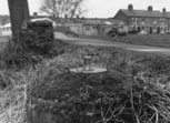
Cross over the bridge and go just beyond the Centenary Walk Plaque.
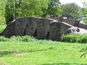
 In the undergrowth, just over the Packhorse Bridge, on the right, are the remains of the spigot mortar gun turret used by the Home Guard during the Second World War
It was one of two situated locally; the other one on the field near the brook, at the Thurcaston Road entrance of Castle Hill Country Park.
These would have been used if Anstey had been attacked by enemy soldiers.
Cross back over the bridge and walk in front of the row of terraced houses facing the brook. At the junction with the main road look over the road.
 At the righthand end of the row of Victorian terraced houses on the opposite side of the road, nearest to The Brook, stood Jack Hancock’s garage. This was one of a number of garages in Anstey during WWII.
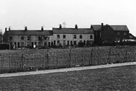
 The lefthand end of the terraced houses (now part of Ned Ludd Close) was the site of 2 Nissan Huts built for the War Agricultural Executive Committee and used from 1939 to 1945. The huts housed tractors and ploughs which were manned by Italian POWs. The huts were taken over by Artisan press, for storage when they moved in in 1951 and were finally demolished in 1974.
Turn left and follow the road towards The Nook.
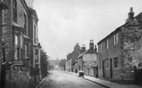
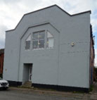
![]() Walking along Leicester Road towards the village centre you pass two buildings that housed some of the earliest shoe factories.
Walking along Leicester Road towards the village centre you pass two buildings that housed some of the earliest shoe factories.
The building that now houses Anstey Funeral Directors was, for many years, the premises of various factories important in the development of the village boot and shoe industry.
The first company to use the building was Springthorpe, Black and Hunt.
This was one of the oldest shoe businesses in Anstey, being established in 1882. The original business continued there until 1889 when it was dissolved and became Springthorpe, Hunt and Company.
This company was wound up in 1926 during the General Strike.
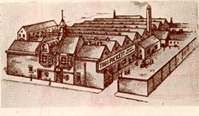 Opposite, the building that now houses Potters Carpets, has been an integral part of the life of Anstey for over 100 years.
In 1906 Thomas Pickett moved the shoe company that he founded in the 1880s, in Latimer Street, to this site and by 1917 it was producing 3,000 to 4,000 pairs of shoes a week.
Both these factories played an important role during both WWI and WWII, making boots for British troops.
 Number 7 Leicester Road was Anstey’s first telephone exchange until the new exchange was built on the Bottom Green. Note the bracket, just to the left of the door, that held the Telephone Exchange sign.
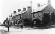
The one exception to the terraced Victorian houses is No 1a. This villa, built in 1886, was the home of Mr Ernest Bosworth, who was the Anstey Parish Council secretary, rate collector and registrar from 1914 to 1947.
You have reached The Nook, which is now the main focus of the village.
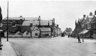 Originally The Nook was the hub between Anstey’s two main roads – Main Street (now Bradgate Road) and Cropstone Road (now Cropston Road).
The 1761 enclosure map of Anstey shows a small structure marked in the centre of the Nook, where the roundabout is today. There is no record of what this building was, but it is now believed to have been a ‘lock up’. This was a small building used for temporary detention usually when official prisons or criminal courts were beyond easy walking distance. Lockups were often used for the confinement of drunks, who were usually released the next day, or to hold people being brought before the local magistrate.
 Until the 1920s The Nook was a wide open-space, surrounded by cottages and shops, often used as a playground for the children of the village. Over the years it has replaced Main Street (Bradgate Road) as the focus of the village.
Originally the buildings around The Nook were cottages, many of them thatched. A number of these were built with steps to prevent them being flooded. These later became shops in the early 20th century with many of the shop keepers living over the premises.
As there was no decent road into Anstey, most shopping was done locally which meant there was a vast array of shops, from food to clothes; much of the produce was supplied locally which accounts for the large number of farms, bakers, butchers, dairies.
This would have been especially important during wartime when there were food shortages.
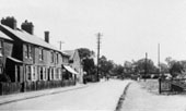
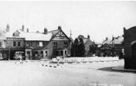
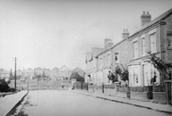
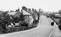
This photograph shows the kerbs which were painted black and white in WWII so they could still be seen in the blackouts.
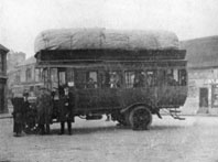 During WW1 transport reverted to either horse-drawn or gas fuelled.
Buses were often fuelled by gas filled bags strapped to their roofs.
The replenishing depot was an underground tank in the yard next to the Methodist Schoolroom, now the Methodist Church.
The Nook also played an important part at the end of both WWI and WWII, when the village came together to celebrate the end of the fighting.
Go across The Nook and walk up Stadon Road.
 Known as Stadon Lane in the 1761 Enclosure Award, the name had disappeared by 1895 when it became Throne Lane. It ran from the Nook to a point approx. opposite the Working Men’s Club (now Sapori, an Italian restaurant).
Originally a cul-de-sac, the road stopped just by the Recreation Ground. Colonel R.F. Martin, who owned the land, built a link road through to Hollow Road/ Ellis Street junction, but because of a dispute with the Parish Council over its upkeep, it was fenced off at either end for a considerable time.
 G.H. Palmer’s shoe factory stood on the corner of Stadon Road and Highfield Street. During WWII the air raid siren and observation post for the whole village was installed into the roof.
This remained until the building was converted into housing in 2007.
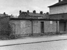
 Further up, on the righthand side, the building between the two housing developments was the headquarters of the Home Guard. The Home Guard was made up of local volunteers who were either too old, too young or medically unfit to fight.
Their primary role was to act as a secondary defence force in the locality in case of invasion by the enemy.
 Next door, where the houses are now, was the site of one of Anstey’s air raid shelters.
It was built centrally so it that people could reach it quickly.
Go past The Hollies on the left and when you reach the next green open space turn left towards Anstey Library.
This large field is known by all Anstey folk as The Reccy.
Villagers fought for many years to have a recreation ground in the village. Even though the subject was mentioned in Parish Council documents as far back as 1928, it was not until 1952 that land was purchased for this purpose. It cost the parish £1,400 which included piping the ditch that had run across the field for many years and levelling out the ridge and furrows. The new Jubilee Hall was built in 2003 to replace the original Memorial Hall, which had stood on the same site.
It was extended in 2024.
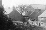
Walk in front of the library, which is built near to the site of a row of terraced houses known as Poplar Terrace or Papermill Row.
These cottages made up one of the ‘yards’ off Church Lane and was connected to Church Lane by the lane running down the side of the building which housed the Adult School. Although named Poplar Terrace on contemporary maps, it was numbered, from 1923 when house numbers began, as Church Lane.
This meant that the people who lived there actually had 3 different addresses for the same house.
Many of the men serving in WWI and WWII would have lived in this area.
Follow the path, go through the gate and turn left and then left again.
 Church Lane, situated next to the church, was part of Anstey’s medieval centre. The area was extended in the late 19th or early 20th century when houses were built for the growing population of workers in the village boot and shoe industries.
 Follow the road until you reach the building which housed the Anstey Adult School on the lefthand side.
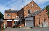
Built in the mid-19th century as a papermill, which traded from 1875 until 1878, it later became a boot and shoe factory, followed by the Adult School & Institute which was in existence for many years.
During WWII soldiers were camped in huts at the top of Gorse Hill on the road between Anstey and Leicester.
On a Friday evening they would be marched down to the Adult School for ‘bath night’. Each soldier would be charged 1 shilling which included soap.
Cross over the road into the churchyard. Follow the path to the front and take the righthand path onto Bradgate Road.
 St Mary’s Church would have played a very important part in the villagers’ lives throughout many conflicts.
In WW11 the bells were to ring to indicate the arrival of enemy parachutists.
It would have been the task of the Home Guard, the military or the police to carry this out.
Luckily this never happened.
The church was also responsible for organising events and initiatives such as knitting for the troops.
Inside the church are memorials to the village men who were killed in both WWI and WWII.
(For a deeper understanding of this area please follow the Bradgate Road and The Nook Trail).
Turn right out of the Church and follow Bradgate Road until you reach the junction with Groby Road.
Detour to Anstey Cemetary (Optional)
At this point you can choose to continue up Bradgate Road or take a detour to visit Anstey Cemetery where there are a number of Commonwealth War Graves.
If you choose not to take the diversion please proceed to the next section.
 Cross over Bradgate Road and go along Groby Road.
Follow the road past the two former farms on the right-hand side until you reach Burgin Road.
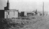
A new road was created to house temporary, prefabricated buildings which were erected in 1940-41 as a wartime measure for evacuees and local people.
The prefabs, also known as Alvis houses, were prefabricated in the Brewery Yard on Bradgate Road and transferred in large sections for erection on site.
The buildings faced down the road looking towards the Mill. Although small, they had built-in kitchens, running hot water and good quality modern bathrooms; far better than that of many of the houses in the village. They were demolished in 1957.
The road was named after Rev. W Roby Burgin, who gave the land for the new Anstey Cemetery in 1886.
Continue to walk along Groby Road until you reach the cemetery.
Cross over the road.
There are 10 Commonwealth Graves in the cemetery, 5 from WWI and 5 from WWII.
They are dotted throughout. The Commonwealth War Graves Commission website gives the location of each one.
Retrace your steps to Bradgate Road. Cross over the road and rejoin the main trail.
Follow the road until you reach the Top Green.
 Originally named Main Street, Bradgate Road was the main street through the village, one way joining what is now Cropston Road through the Nook and the other way as Newtown Lane towards Newtown Linford. Until the latter part of the 19th century, this area would have been very rural; just fields and farms, interspersed with cottages.
It was from this main road that most of the village roads radiated and St Mary’s Church was the centre of the medieval village.
This was the area where most of the population originally lived; the village only expanding with the coming of the boot and shoe industry in the 19th century.
A number of the original buildings remain, although most now have different uses; many being renovated for residential use.
 On the right-hand side are the premises of Ulverscroft Books which are built on the site of the old ‘Tin Hut’.
During WW1 the Anstey Citizens Defence Force (the forerunner of the Home Guard) was organised and drilled in the ‘Tin Hut’, which became known as the Drill Hall.
A shortage of weapons meant that the men had to train with broom handles.
Turn right and follow Hollow Road.
 Hollow Road was originally a cul-de-sac named Hollow Lane, which led from The Green to a point just past the Stadon Road junction. The top end of the road was a fenced off field with a pond and a large elm tree until the council houses were built in the 1950s.
These were built as part of the British government’s rehousing scheme after WWII.
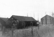
 On the right-hand side were the premises of Bosworth and Wright Box Factory.
During WWII the factory was used to make Aircraft parts for Alvis, a Coventry company that outsourced work during the war.
The box factory closed in 2025 bringing the end to all traces of the shoe industry in Anstey.
Continue until you reach the junction with Stadon Road and Ellis Street.
 Ellis Street, to the left, was until 1899 known as Martin Ellis Street, named after two of Anstey‘s most prominent families. After this date the Martin name was dropped.
The Martin’s were wealthy landowners; the Ellis’s were not only wealthy, but were also liberal, as were they majority of Anstey at the time and it is believed that this is the reason the name was changed.
The building called Regent House, on the left-hand side of Ellis Street, was the second of Anstey’s two cinemas.
The cinema was originally known as The Picture House, which showed silent films. It was a corrugated iron building with wooden benches and was opened and run by Mr F Grimsley.
In 1938 it was rebuilt in its present form by Mr and Mrs Rodwell and renamed The Regent. It finally closed down in 1959.
The cinema was known by the villagers as ‘up top’ as opposed to The Savoy which was ‘down bottom’.
It, along with The Savoy on Cropston Road, would have played an important part in entertaining the villagers during WWII.
Now turn right down Stadon Road. Follow the road until you reach the War Memorial on the right-hand side.
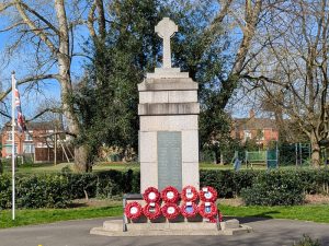
In 1919, the Parish Council discussed three alternatives for a memorial to those who had lost their lives in WW1; public baths, a village hall or a memorial in The Nook.
In the end Anstey War Memorial was erected on land given by the Martin Family.
It was built using Mountsorrel granite and Swithland slate and was dedicated on 7th May 1921. The village sexton, Mr. T. Moore, was appointed caretaker at 5s per week.
At the end of WWII, 25 names were added to the 114 already on the memorial.
 The nearest Anstey came to being bombed during WW2 was in 1940, when a German plane returning from a raid on Coventry, dropped a bomb close to the path between Anstey and Cropston, just inside the perimeter of Fairhaven Farm.
The crater was filled in very quickly by the farmer as he said he didn’t want people coming onto his land to look at it!
You have completed the Wartime Trail
Time: Approx. 1 hour plus any time spent visiting the Cemetary
More details about the soldiers on the memorial can be found in the Roll of Honour on our War Memorial Project.