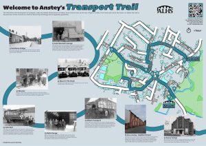
Transport Trail
Introduction to Transport in Anstey
The name Anstey is derived from the Saxon name ‘Hanstige’, meaning the high path, which had been altered by the time of the Domesday Book in 1086 as ‘Anstige’ meaning the narrow forest track.
These names give an indication to why Anstey is located where it is.
The only way to move around at this time would have been on foot, following small tracks.
The footpath, that runs from Gynsill Close, over the Packhorse Bridge was probably Roman. In the earliest times the brook would have been crossed at a ford until the Packhorse Bridge was built in the 15th century.
The other main track, from Leicester, was Sheepwash Lane, at the other end of the village where King William’s Bridge was built, at the same time.
Some of Anstey’s original tracks still exist, even though they now have different names. Some have developed into roads, others are still tracks.
Many roads exist as a result of the ‘Enclosure Act’.
The lower end of Park Road remains the only unadopted road in the village; it gives a good impression of how the roads would have been in Anstey’s early years.
At one point, at the end of the 19th century, there was a plan to bring a railway line through the village. After much discussion this did not materialise.
Until the mid-19th century, transportation would have been by cart ‘mule packs’ or on foot.
It was at this time that carriers, to and from Leicester, began to appear due to the growing industry in the village.
These began as horse and carts, moving to carriages and finally horse brakes, which were the first buses.
As people’s lives changed so did the local transportation.
Bicycles and motorbikes became popular.
More motor cars meant that garages and servicing were needed. At one time, after WWII, there were seven places in Anstey where you could buy petrol.
Horse and carts were no longer suitable for the growing village industrialisation and so more modernised haulage companies were founded.
People wanted to travel longer distances and finally, in 1923, the road over The Goss (the road past Gynsills Tennis Club) to Leicester was metalled.
It is your responsibility to be aware of whether you are allowed to access any area, to follow the Highway Code, and to be observant of any hazards which may be present along or near your route.
If you experience any issues while following the trail please Contact Us and provide a description.
We hope you enjoy the trail and we would really appreciate your feedback.
Map showing Start of Trail
Map view of the Transport in Anstey Trail starting point
Street view of the Transport in Anstey Trail
Clicking the links will either open a new tab on your browser or the Google Maps app
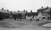
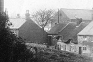
Begin the Trail on the Bottom Green, standing on the Packhorse Bridge.
 The Lower or Bottom Green is one of Anstey’s two ‘greens’ and the Anstey (Rothley)Brook runs through here.
The name Anstey is derived from the Saxon name ‘Hanstige’, meaning the high path, which had been changed by the time of the Domesday Book in 1086 to ‘Anstige’ meaning the narrow forest track.
Both names give an idea of the terrain surrounding Anstey at the time.
It is understood that the track over the Packhorse Bridge is earlier, probably Roman.
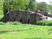
The Packhorse Bridge, (where you are standing) is one of two such bridges that are found in Anstey.
One of the oldest structures in the village, it is believed to date from around 1500.
It is one of the best-preserved packhorse bridges in Britain. Note the V shaped features which enabled people to move out of the way of the laden pack horses as they passed. Hence its name.
 The main road bridge, is thought to be the third bridge built in this position. The first was a stone bridge built to replace a ford. When this bridge was badly damaged in 1924 by a Great Central Railway lorry it was replaced with a concrete structure.
In 1995 it was upgraded to meet European axle weight standards.
Next to it, is a gas pipe laid down in 1895 when gas was brought to the village.
Leave the Packhorse Bridge walking in front of the row of houses facing the brook until you reach the main road.
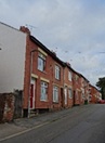
Look across at the row of Victorian terraced house on the opposite side of the road.
 Leicester Road has always been a direct way into Anstey from Leicester, even though it was not metalled until 1923.
At the brook end of the terraced houses was the garage, where Mason’s bus was garaged. This bus service, in the 1920s, operated 7 days a week to Leicester.
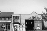 In the 1930s the building was taken over by Jack Hancock, who was also the owner of Anstey Haulage Company. It was demolished in the 1970s.
Jack Hancock originally worked for Geary’s Box Factory on Park Road.
One morning in 1931 he turned up for work to find the factory burning.
He raised the alarm but as a consequence of the fire, found himself unemployed.
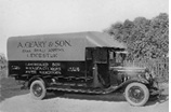 Mr Geary asked him if he could do anything with a Chevrolet 30 cwt van.
Jack took it, converted it to a flatbed lorry and began a very successful business.
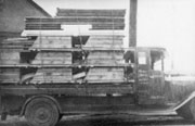 As the fleet of lorries grew, larger space was needed and the company moved to a yard next to Broughton’s Timber Yard, on Edward Street, close to Link Road and where Broughton Close is today.
Turn left and follow Leicester Road until you reach The Nook.
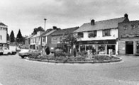
 The Nook originally joined Anstey’s two main roads – Main Street (now Bradgate Road) and Cropstone Road (now Cropston Road).
The 1761 enclosure map of Anstey shows a small structure marked in the centre of the Nook and labelled ‘Stamford’, where the roundabout is today. There is no record of what this building was, but speculation is that it could have been a market hall or cheese market.
More probably it was a lock up; somewhere to hold people until they were able to be removed to a court or to hold drunks overnight until they were released next day.
The Earl of Stamford was a major landowner in the area at this time.
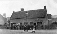
 Until the 1920s The Nook was a wide-open space, surrounded by cottages and shops, often used as a playground for the children of the village. Over the years it has replaced Main Street (Bradgate Road) as the focus of the village.
The early buildings around The Nook were cottages, many of them thatched. A number of these were built with steps to prevent them being flooded. These later became shops in the early 20th century and most of the shop keepers lived over the premises.
 At the beginning of the 20th century the Great Central Railway had a parcel receiving office in Anstey, serving its nearest station at Rothley.
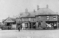
The Nook quickly became a hub for traffic and it has always been the place to ‘catch a bus.’
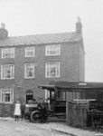
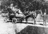
 The development of transportation can be seen in these 2 photographs.
In 1906 there is a wagon and horse delivering to the shops.
60 years later the site is a garage belonging to Doug Naylor.
The business had been started by his father, Bert, on Cropston Road, before moving to the Nook.
The person mending the car is Derek Sturgess; his family business started in 1897 in Leicester.
It is still in business and has a garage on Cropston Road.
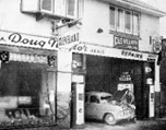 By the 1980s the premises had become ‘Storm’, selling Lotus cars.
Continue to walk up Bradgate Road, towards the church.
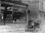 No 3 Bradgate Road was originally George Moore’s shop.
He sold and repaired bicycles, a main means of transport at the end of the 19th and into the 20th centuries.
He is believed to have had one of the first motor cars in Anstey.
 The tall house. No 30, on the left-hand side was Lowens Bicycles, from where later generations of villagers bought their bikes.
Turn right into Church Lane which is just before the church and walk until you reach the garage at the end of the Victorian terrace.
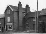
 Church Lane, one of the ancient roads in Anstey, is situated next to the church and was part of the medieval centre of the village.
Most of the surviving houses in Church Lane were built in the late 19th or early 20th century for the growing population of workers in the village boot and shoe industries. There were a number of alleys and yards leading off, with names such as Kidney Bean Alley, Wells Yard and Clarkes Yard as well as Papermill Row. A large number of these houses have now been replaced with modern builds. However, enough remain to give an idea of what the area would have been like. The present numbering of the houses shows how many of the original houses have disappeared since 1923.
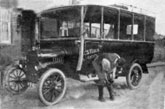
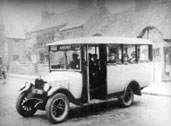
The first carriers (early buses) in Anstey were horse drawn, known as brakes and reserved for the more affluent villagers.
Maurice Reeson was one of the first owners of such a vehicle as were Joseph Arguile and Mahlon Wolfe.
These vehicles would take people to and from Leicester.
In 1906 Reeson built stables on this site to house his horses and coach.
He gradually added larger vehicles and finally he had a brake which could hold 34 passengers.
 In 1910, Reeson introduced the first full- sized motor bus to Leicester from Anstey, which was given the nickname ‘John Bull’.
The vehicle was an old London bus. On its first journey to Leicester, John Bull stalled on one of the hills and the passengers had to get out and push.
‘John Bull’ was sold to other companies and was believed to have been destroyed.
However, in 1984 its body was discovered by the late Greg Duffin of Stonehurst Farm, Mountsorrel. Over the years Greg and his son Tom restored the bus to its former glory.
In 2019, Channel 4 featured ‘John Bull’ on its programme, ‘Great British Car Journeys’, presented by Peter Davidson and Christopher Timothy.
The bus still operates today, giving people the chance to experience riding on an early 20th century bus.
 In 1911 the company was taken over by Johnny Hutton, who had been one of Reeson’s drivers and he continued to use the garage.
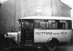 The company evolved from a carrier with a horse, to a fleet of motorised buses and delivery vehicles that served Anstey for many years.
Go into Caters Close and then turn right through the gate into the large field known as The Reccy. Walk across the field to the road on the opposite side, Stadon Road. Turn left and follow the road to the T - junction with Hollow Road.
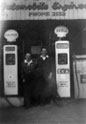 On the corner of Hollow Road and Stadon Road was Botts Garage.
This company was originally established in the early 1920s by John Lewis Bott as a business for selling, maintaining and repairing radios in his home and shop.
Later, with his sons, Lewis Jn, Frank and Trevor he started a garage business. Firstly, with a garage for cycles and then a larger building for motors together with petrol pumps. It was one of seven garages where, post WWII, you could buy petrol in Anstey.
They also started a haulage business in the 1930s with Commer, Vulcan, and finally Leyland Comet vehicles.
 In 1968 a new garage was built on the opposite corner which remained until it closed down in 1987.
Retrace your steps back down Stadon Road.
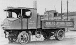
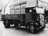
Stadon House, on the left-hand side, was the home of Horace Elliot who had begun his working life at his father’s building business in Leicester.
In 1921, he bought a piece of land on Stadon Road from his father-in-law, George Harry Palmer, who lived in ‘The Hollies’, just past the Reccy, and was the owner of Palmers shoe factory, on the corner of Stadon Road and Highfield Street.
In the beginning this was used as a builder’s yard where he kept one vehicle in a shed at the back.
He began to extend his fleet and then, in the 1920s, began to operate steam lorries. However, by the 1930s such lorries had become obsolete and Elliott replaced them with a variety of non-steam lorries.
He finally sold his business in 1947.
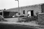
Continue to walk down Stadon Road, past The Hollies until you reach the new build, next to Anstey Home Crafts.
 This was the site that Elliott bought and which became the garage for his lorries.
It was a corrugated iron clad roofed building and finally closed in 1951, after which it became a building for storage.
Turn into Highfield Street, then turn left into George Street and then right into Edward Street.
 This area, known as New Anstey, was built as housing for the expanding shoe and boot workers. Most of these workers were employed by George Harry Palmer in his factory at the bottom of Highfield Street.
Note that the roads are wider than the original village roads.
This was needed for the vehicles delivering to the growing number of factories.
Walk along Edward Street until you get to the junction with Albion Street.
Turn right.
The row of terraced houses on your left was built in 1928 by Horace Elliott, to provide homes for his drivers.
The houses were originally rented, but when the business was sold, they were gradually bought by the residents.
Walk to the bottom of Albion Street, where it joins Cropston Road.
 The garage opposite is Sturgess garage. One of the few remaining garages in Anstey.
Turn right and follow the road towards The Nook.
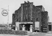
Broughton’s Ironmongery Shop, on the left-hand side, is the site of The Savoy Cinema, one of two cinemas in Anstey.
It was originally called The Coronet and the building of the cinema was completed in 1937, the year of the coronation of King George VI and Queen Elizabeth.
The Savoy Cinema closed in the 1960s and was converted into use as a garage and filling station which closed in 1988.
It then became a fine dining restaurant, followed by an Indian restaurant, before Broughton’s moved into the building in 2002.
You have completed the Transport in Anstey Trail
Time: Approx. 1 hour