Industry Trail
The first industry in Anstey was farming and its associated services.
From Saxon times the land was open and common; the land that was cultivated was worked as a strip system.
The Norman invasion of 1066 changed the landscape. King William divided the land among his relatives and friends, which meant the villagers became serfs, semi slaves.
Each man worked for himself, his family and for his overlord.
These serfs had to give their lord 40 days’ work a year and the lord’s work took priority. At ploughing and harvesting times the lord’s work would need to be completed first, before any of their own.
They were also expected to send their corn to the lord’s mill.
Even bread was baked in a communal oven owned by the lord.
Men could free themselves, either by buying themselves out or by running away and hiding for a year and a day.
The first reported free man of Anstey was Robert Martin in 1301.
The earliest recorded date for a mill at Anstey is 1306, but it is believed that there must have been one in existence even earlier.
By 1800 the domestic framework knitting industry had taken a hold in Anstey, reaching its peak in 1845 when 300 knitters were recorded. The knitting frames were mostly too big to fit in the cottages, so were housed in backyard sheds and outbuildings; the larger of which were known as ‘stockingers’ shops.’
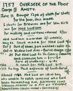
This industry will always be associated with one of Anstey’s most remembered residents, Ned Ludd. Ned Ludd is believed to be Edward Ludlam who lived in Anstey in the mid-18th century. Records show that he was of lowly birth; probably of low intelligence and frequently received help from the poor relief.
It is said that Ned destroyed some stocking frames in a fit of temper after being unable to catch a person who had been tormenting him. The parish records show that 19 shillings was paid for his burial on the 31st August 1776 and he is buried in a pauper grave in St Mary’s Churchyard. Stocking frame workers took his name much later in the 19th century when, in protests with their managers, they destroyed stocking frames and called themselves Luddites.
By about 1850 the stocking trade was in decline as the rise in factory-made stockings meant that the knitting cottage industry was no longer viable. The villagers transferred their skills to the new boot and shoe manufacturing and although much work was done in factories, the ‘finishing’ was often carried out in back yard workshops. These were behind the new terraced houses which had been built by the factory owners to house their workforce.
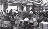
Between 1860 and 1900 Anstey’s population soared from 768 to 2,544 due to these industries. As well as the factories, other associated industries were needed such as box factories and haulage, examples of which were established in Anstey. In the 1895 Trade Directory 23 shoe factories were recorded.
G.H. Palmer, Pollard and Wain (later Airborne Shoes) and Diana Shoes were not only well known in Anstey but also nationwide.
The last shoe factory, Burton and Stone, closed down in 1976.
As the boot and shoe industry declined other industries took its place, one of which was printing, with Artisan Press, Ulverscroft Press, Norwood Press and Suburban Press all employers.
By the end of the 20th century both industries and services had declined further. As people began to travel to work outside of Anstey, it became a ‘commuter village’.
The 21st century has brought a further decline in industry and services, in spite of the large rise in population. A large number of old buildings still remain, but now have different functions.
It is your responsibility to be aware of whether you are allowed to access any area, to follow the Highway Code, and to be observant of any hazards which may be present along or near your route.
If you experience any issues while following the trail please Contact Us and provide a description.
We hope you enjoy the trail and we would really appreciate your feedback.
Map showing Start of Trail
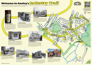
Map view of the Anstey Industry Trail starting point
Street view of the Anstey Industry Trail
Clicking the links will either open a new tab on your browser or the Google Maps app
Begin the trail on The Top Green and stand between Hollow Road and Forest Gate, facing the main road.
 This area is one of Anstey’s two ‘greens.’ Known as The Green or The Top Green. It has always been an important area of the village and was mentioned on the Enclosure Map of 1761 when it was common land.
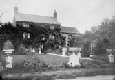
Originally very rural, The Green was surrounded by farms and cottages. Some thatched and some slated, some dating to the 15th century. The large Georgian house in front of you is an exception.
Farming was the earliest ‘industry’ in Anstey, dating back to Saxon times. Almost all villagers would have been involved in farming, most of them described in census returns as agricultural labourers.
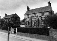
 Green Farm (straight ahead) is said to be the oldest domestic building in the village and parts of it are proved to date to the 15th century. The more modern house adjoining it, was built about 1800.
The farm originally belonged to the Martin Family and then by subsequent families until farming ceased in 2002 when it became the last farm in Anstey to cease working.
 At the top end of The Green, Manor Farm, originally belonged to Ulverscroft Abbey until the land was allotted to the 7th Earl of Stamford (Grey Family of Bradgate) as a result of the Enclosure Award in 1762.
One of the tenants, around 1910, was a man named Jackson who was a notable breeder of Shire horses.
In November 1925 the farm was bought at the Bradgate Sale by George Pettifor for his son William for £3000. Later, it was run by Mr Wilf Poole.
 On the left-hand side, the premises of Ulverscroft Books is built on the site of the old Drill Hall.
Previously, this building had been the first site of Bosworth and Wright Box Company, founded in the 1920s by Arch Bosworth and Ernest Wright.
The company later moved to purpose-built premises on Hollow Road in 1934 and continued until 2025 when it ceased trading.
 The Ulverscroft Book Group was established in 1964 by Dr Fred Thorpe.
Before WWII, Dr Thorpe operated a mobile library in Leicester, using a three-wheel Raleigh van and charging 2 pence per book, per week.
After the war, he returned from the RAF and began publishing British editions of American magazines. A chance encounter with a local heath visitor made him aware of the fact that declining eyesight was preventing elderly people reading and he decided to do something about it.
The Ulverscroft Group is now the world’s leading publisher of large print books, publishing 64 large print titles a month and distributing even more.
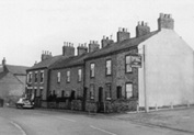
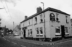
Follow the main road down the hill past The Crown public house.
 Originally named Main Street, Bradgate Road was the main street through the village, joining what is now Cropston Road through the Nook. The other direction was Newtown Lane towards Newtown Linford.
Until the latter part of the 19th century, this area would have been very rural; just fields and farms, interspersed with cottages.
It was from this main road that most of the village roads radiated and St Mary’s Church was the centre of the medieval village.
This was the area where most of the population originally lived; the village only expanding with the coming of the boot and shoe industry in the 19th century.
A number of the original buildings remain, although most now have different uses; many being renovated for residential use.
 Pettifor Court Retirement Complex, on the left-hand side of the road, is built on the site of Anstey Brewery.
The brewery was established in the 1840s by Samuel Burchnall. Later it was taken over by John Doleman and finally by Daniel Pettifor and known as Anstey Maltings and Steam Brewery, noted for its double stout and ales.
When the business was sold in 1900 to Marston’s Beer, the company’s advert describes it as ‘a three story malthouse with a dwelling house, 5 cottages and a large plot of adjoining building land.
Many of the drinking establishments in the village were run by the brewery.
 Next to The Crown, were two rows of back-to-back houses, with a shared row of earth closets. They were built by the Pettifor family for their brewery workers and were known as Pett’s front and backs. These were demolished in the middle of the 20th century and replaced with the modern houses you can see today.
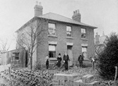
 The house on the right-hand side, sideways to the road, is No 102, The Woodlands. Built around 1800, it was a farmstead originally farmed by the Astill family.
Later it was owned by Daniel Pettifor of Anstey Brewery, becoming the home of his son Stanley, who was a dairy farmer.
His ‘Woodlands Dairy’ was based at his farm and his cows grazed at various points around the village. He delivered milk around the village until 1949 when Wilf Poole of Manor Farm took over delivering the village milk.
Turn right into Groby Road.
 This road was originally named Groby Lane and many of the older village population still refer to it as so. Until the middle of the 20th century it was a country lane with buildings only as far as the end of the bungalows, which were erected on the site of allotments.
Two more of Anstey’s farms were located here; Heard Farm, later Sibson’s Farm and The Limes Farm, also known as Lime Tree Farm, both on the right-hand side.
 Heard Farm, on the corner with Bradgate Road, was built in 1767 for Mary Heard, the daughter of John Heard, a gentleman from Billesdon and his wife Ann.
Mary was one of the two main landowners in Anstey, which was very unusual for a female at this time.
When she died in 1803, unmarried, she left £600 to be invested and the income be divided between 3 parishes, Anstey being one of them. She directed that this was to be used to buy shirts and shifts for the poor.
Her large railed tomb is in St Mary’s Churchyard.
 The second farm, The Limes, was built in the late 16th or early 17th century.
Both farms remained as working farms until late into the 20th century.
Return to Bradgate Road, cross over the road and continue to walk down the hill.
 On the corner of Church Lane was The Plough Inn, which dates from the 1880s and originally only served beer. It is now housing.
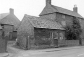
 Till’s Butchers, another of Anstey’s 18th century farms, was converted to a butcher shop in 1896 to meet the needs of the expanding population.
When originally built, the farmhouse would have consisted of both the butchers and the Chinese Takeaway next door and the farm’s land would have covered the whole of the area between Church Lane and the track beyond the hairdressers, as well as the land behind.
Note the tiled frontage.
The earliest farmer/ butcher registered is George Perkins Snr in 1867. In the 1881 census he is shown as farming 25 acres and employing 3 men, 2 boys and a female domestic servant.
When you reach the hairdressers, cross back over the road and turn into Park Road.
 In the 19th century, framework knitting had become a major industry in Leicestershire, probably due to the abundance of good quality wool in the area. By 1800 the domestic framework knitting industry had taken a hold in Anstey, reaching its peak in 1845 when 300 knitters were recorded.
The knitting frames were mostly too big to fit in the cottages so were housed in backyard sheds and outbuildings; the larger of which were known as ‘stockingers’ shops.’
These were single story buildings with large oblong windows to provide optimum light.
Although the industry subsequently gave way to the boot and shoe industry, there were still ‘shops’ being used well into the 20th century.
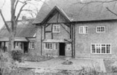
 No 3, Park Road, Mafeking House, is one such example. Built by George Lowe, a hosiery manufacturer, in 1874, it had a shop behind it.
This housed up to 8 knitting frames, of which two were still used up to WW1. The stockings were sold in Leicester.
Return to Bradgate Road, cross over the road and go into the Churchyard. Follow the path to the left of St Mary’s Church.
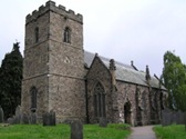 The first stone church was built on this site in the 14th or 15th century. The restored tower and doorway at the rear of the church are the only part of that building remaining. The rest of the church was rebuilt at a cost of £4,000 between 1845 and 1846 at the expense of the then rector, Reverend Richard Waterfield, to accommodate Anstey’s rising population.
(There is a separate trail for the church and churchyard, please click here if you wish to switch to the church trail, or continue reading below for the industry trail).
The area of the Churchyard behind the church, leading on to Church Lane, was for the burial of village non-conformists, those people who did not attend St Mary’s Church, and the site of the village Paupers Graves.
 This is where one of Anstey’s most well-known villagers was laid to rest.
Ned Ludd, believed to be Edward Ludlam, lived in Anstey in the mid-18th century.
Records show that he was of lowly birth; probably of low intelligence and frequently received help from the poor relief. It is said that he destroyed some stocking frames in a fit of temper after being unable to catch a person who had been tormenting him.
The parish records show, that 19 shillings was paid for his burial on the 31st August 1776 and he was buried in a pauper grave in the Churchyard.
Stocking frame workers took this name much later in the 19th century when, in protests with their managers, they destroyed stocking frames and called themselves Luddites.
From about 1850 the stocking trade declined as the rise in factory-made stockings meant that the cottage industry was no longer viable.
Walk through the far gate into Church Lane.
 Church Lane, another of the ancient roads in Anstey, is situated next to the church and was part of the medieval centre of the village.
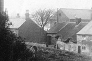
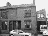
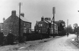
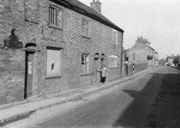
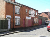
Most of the surviving houses in Church Lane were built in the late 19th or early 20th century for the growing population of workers in the village boot and shoe industries. There were a number of alleys and yards leading off, with names such as Kidney Bean Alley, Wells Yard and Clarkes Yard as well as Papermill Row. A large number of these houses have now been replaced with modern builds. However, enough houses remain to give an idea of what the area would have been like. The numbering of the houses indicates how many of the original have disappeared since 1923.
 The building next door to the Church Rooms, to the left as you look, was the village Adult School.
This building has had a long and varied life.
It was built around 1873 as a papermill, known as Anstey Paper Company Ltd, for the production of brown paper.
This was possibly to wrap the stockings, shoes and boots that were being produced in the village.
It was established and overseen by a company based in Lancashire.
The Anstey enterprise was launched in March 1875, run by Mr John Staines, but by 1878 it had become bankrupt and closed.
 By the mid-1880s most papermills were highly mechanised. Anstey, however, was still using traditional raw materials and older technology.
Added to this, there was very little history of papermaking in Leicestershire, so the workforce was having to learn from scratch. A further issue was a shortage of water in the area.
The row of houses, behind where the library is now, known as Papermill Row, was built for the workers.
After the closure of the papermill, the building became a boot and shoe factory, followed by the Adult School & Institute for many years. After WWII it was an extension for the growing Artisan Press which was based on Leicester Road.
Follow Church Lane to the bottom, cross over Bradgate Road at the traffic lights and follow ‘The Jetty’ until you reach Latimer Street.
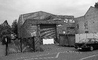
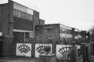
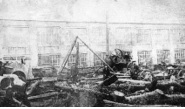
 The building on the left-hand side of The Jetty originally housed a number of boot and shoe factories; later it was the site of Harry Robert’s Tannery.
This company, established in 1923 in Leicester, moved to Anstey in 1937 because of a number of local boot and shoe factories in the village were empty and premises were easy to find.
It was the last business of its kind in the county when it closed and was demolished in 2006.
 Latimer Street has been important, not only in the development of the boot and shoe industry, but was also the site of associated industry.
 Two box factories were located here; Pollards Boxes, established in the early 20th century and trading until the 1990s and Kenilworth Box which ceased trading in 2006.
Follow the path between the school buildings until you reach The Green. Cross over the Packhorse Bridge and turn right into the small field with picnic tables and stand with your back to the brook and look to the right.
 The Lower or Bottom Green is the other of Anstey’s two ‘greens’. The Anstey (Rothley)Brook runs through here.
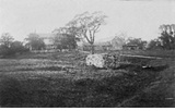
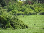
The field closest to The Green was previously known as the Millfield and is a good example of a ridge and furrow system dating back to Saxon times; the first way of farming in the village.
In this system, each man had several widely separated long, narrow pieces of land which measured 16’ x 220 yards which were separated by drains of furrows.
The standing stone in the left- hand corner of the field is believed to be an ancient marker.
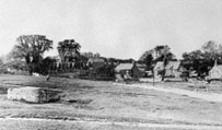
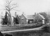
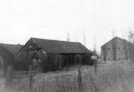
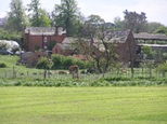 To the right can be seen Anstey Mill.
The earliest date for the mill at Anstey is 1306, but it is thought that there must have been one in existence even earlier.
There is written reference to a mill and attached meadow producing rents of 50 shillings in 1341 and 33 shillings and 4 pence in 1477.
The present building is believed to have been built about 1800 when the stream may have been widened and the bank built up to provide sufficient water to drive a larger waterwheel.
It ceased work in the 1950s and is now housing.
Cross The Green in front of the row of terraced houses to reach Leicester Road and turn left.
 Leicester Road has always been a direct way into Anstey from Leicester, even though it was not metalled, over The Goss, until 1923.
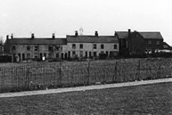
The houses facing The Green and those around the corner on Leicester Road were built at the end of the 19th century to house the expanding village population and are traditional Victorian brick-built terraced houses with slate roofs.
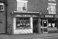
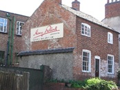
 On the right-hand side of the road, the building that now houses Potters Carpets, has been an integral part of the life of Anstey for over 100 years.
Originally this was known as the Bridge Works and was used by a number of shoe factories.
The last shoe company moved out in the early part of the 1930s.
In August 1951 Artisan Press moved into the premises. This company had been founded in 1939, just before the outbreak of WW2, at Conduit Street in Leicester by Leslie Sankey, a trained letterpress machine minder, but it didn’t commence business in Anstey until 1945.
It became one of village’s top businesses and employed many Anstey people.
The company moved to new premises at Beaumont Leys in 1980, where it remained until it closed in 2014.
You have reached The Nook, which is now the main focus of the village.
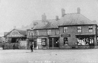
The Nook, originally, joined Anstey’s two main roads – Main Street (now Bradgate Road) and Cropstone Road (now Cropston Road).
The 1761 enclosure map of Anstey shows a small structure marked in the centre of the Nook and labelled ‘Stamford’, where the roundabout is today. There is no record of what this building was, but speculation is that it could have been a market hall or cheese market.
More probably is that it was a lock up; somewhere to hold people until they were able to be removed to a court or to hold drunks overnight until they were released next day.
The Earl of Stamford was a major landowner in the area at this time.
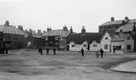
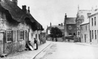
Until the 1920s The Nook was a wide-open space, surrounded by cottages and shops, often used as a playground for the children of the village. Over the years it has replaced Main Street (Bradgate Road) as the focus of the village.
The early buildings around The Nook were cottages, many of them thatched. A number of these were built with steps to prevent them being flooded. These later became shops in the early 20th century and most of the shop keepers lived over the premises.
As there was no decent road into Anstey until the 20th century, most shopping was done locally. This meant there was a vast array of shops, from food to clothes. Much of the produce was supplied locally which accounts for the large number of farms, bakers, butchers, dairies recorded.
Most of these buildings have now disappeared, but the café on the corner of Cropston Road gives an indication of how the original buildings would have looked. Even though some shop fronts have changed, the roof line of many of these premises remain.
Turn right and follow Cropston Road towards Cropston.
 The alleyway next to No. 4 Cropston Road, was the entrance to Norwood Press Printing Company which was located in the building at the rear.
This was one of a number of printers that were established in Anstey.
The business was started in 1951 by Leslie Savage and remained in Anstey until 2007 when they moved to larger premises in Ellistown.
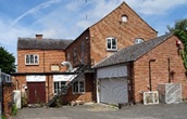
 The next group of buildings, now a gated residential complex, was another of Anstey’s farms, Elms Farm.
Sam Burchnall, a major landowner in the village, first moved into the 17th century farmhouse, while the adjacent farmhouse, which appears in the Rate Books for the first time in 1834, was being built.
The property remained in the family until the death of Miss Pratt, the last inhabitant, when the house and all of the outbuildings were sold. It was subsequently restored and developed in 2004.
The 17th century farmhouse became known as ’The Mews’. There is evidence of the roof being raised to provide an upper floor, together with the period diaper brickwork and the bricked-in window which was probably the result of avoiding the window tax imposed by King William III in 1696. A tax that gave rise to the phrase ‘daylight robbery’.
 The buildings both sides of the Co-op site would have been cottages; one of which, owned by Jack Smith is known to be one of the last framed knitting cottages in the village and had the characteristic long windows which allowed optimum light to enter.
 The housing estate further along on the right, is built on the site of Melody Mills Wallpaper Factory; notice the street names.
The factory was started in 1934 in Sileby but during WWII the premises were burnt out. New owners took over in 1945 and in 1948 changed its name to Melody Mills Ltd.
The company expanded to Anstey in the 1970s and 10 years later had a work force of 100.
Melody Mills went into receivership around 1982 and the company became Anstey Wallpaper Company. This closed in 2001.
 Previous to Melody Mills, the first factory on the site was Marwins Engineering.
This company was founded by Ernie Hopwell and Derek Robinson in the mid-1950s on the Bottom Green, naming it after their wives – Margaret and Winnie. They made precision tools for the aircraft industry in the days of the Comets.
As the company expanded, it moved into large corrugated sheds on Cropston Road, before erecting a permanent building on this site.
Continue until you reach Gladstone Street and then turn left.
 The housing development on the left-hand side (Pack Horse Court) is built on the site that was, firstly, a shoe factory established in 1885.
In the 1930s the factory became Marston Oil Works which closed around 1980 and became the premises for Waltons Powders.
Walk up Gladstone Street; turn left into Andrew Road and then right into Albion Street.
 The factory, half way up on the left-hand side, was built for Lewis East Ltd, Midland Envelope Mills. This company was started by a 19-year-old Lewis East, in 1919, in a rented chapel room in Huncote.
In 1929 the company moved to Anstey having bought a plot of land in Albion Street where the company continued to expand.
In 1971 the business received the Royal Warrant as manufacturers of stationery to Queen Elizabeth II.
In 1983 it acquired The Suburban Press printing company and finally closed down in 1995.
 The corner of Albion Street and Rosebery Road was the site of Broughton’s Timber Yard, another of Anstey’s long-standing businesses. The company began business on Bradgate Road in the early 20th century before moving to Rosebery Road.
In the late 1940s the company relocated to Upper Edward Street (near its Link Road end), where it remained until it closed down and Broughton Close was built on the land.
Turn left into Edward Street. When you get to the end, turn left and then right into Highfield Street.
At the end you reach Stadon Road. The trail is complete.
Time: Approx. 1 hour
If you want to explore St Mary’s Church and churchyard, please see separate trail
For more specific information on Anstey’s most famous industry, you may also enjoy the Boot & Shoe Trail.