Bradgate Road & The Nook Trail
By the 18th century, most of the land in Anstey was owned by local farmers.
Anstey became a village with two nuclei: one around the Top Green and the other around St Mary’s Church. A third nucleus later developed around The Nook.
All three were joined by Main Road (now Bradgate Road) and it was here that most of the village services were found.
Anstey was a self-contained village as there were few decent roads in and out.
As well as food being produced locally, Anstey relied on its hosiery and boot and shoe industries to provide clothes and footwear.
The majority of the population lived between these nuclei and this is where most of the services were located.
As the village population expanded the need for more services meant that the cottages in The Nook were turned into shops and businesses as well as homes.
Gradually, this expansion widened to include cottages and houses from other parts of Anstey, especially after New Anstey was developed at the end of the 19th century.
The trail concentrates on the area between the Top Green and The Nook, showing how many different services worked together in a small area.
If you want to find other examples of services in other parts of Anstey, visit any of the older village streets and you’ll see evidence of an earlier trade.
It is your responsibility to be aware of whether you are allowed to access any area, to follow the Highway Code, and to be observant of any hazards which may be present along or near your route.
If you experience any issues while following the trail please Contact Us and provide a description.
We hope you enjoy the trail and we would really appreciate your feedback.
Map showing Start of Trail
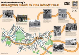
The board for this trail is installed on the fence of Ulverscroft Books, opposite the Crown Inn on Bradgate Road.
Map view of the Bradgate Road & The Nook Trail
Street view of the Bradgate Road & The Nook Trail
Clicking the links will either open a new tab on your browser or the Google Maps app
New Feature: You can now click on any of the images for this trail to view a full sized photograph on screen in a lightbox, and click again to close it.
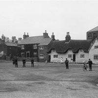
Begin the Trail on the Top Green.
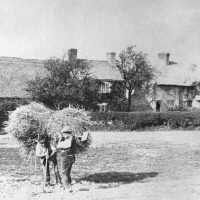 This area is one of Anstey’s two ‘greens.’ Known as The Green or The Top Green, it was one of the main parts of the village.
The area was mentioned on the Enclosure Map of 1761 when it was common land.
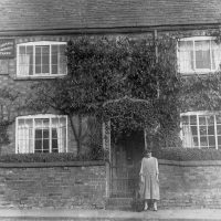
 Originally very rural, The Green was surrounded by farms and cottages, some thatched and some slated, some dating from the 15th century.
Most of the people living here would have been employed by the village farm owners as agricultural labourers.
They would have had large families and low wages.
In the centre of the green is the village well. It is believed that the wall surrounding it is medieval.
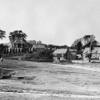
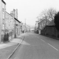
Follow the main Bradgate Road down the hill, past The Crown Inn.
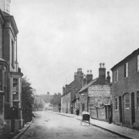
 Originally named Main Street, Bradgate Road was the main street through the village, joining the now Cropston Road through the Nook and Newtown Lane towards Newtown Linford.
Until the latter part of the 19th century this area would have been fields and farms, interspersed with cottages.
It was from this main road that most of the village roads radiated and St Mary’s Church was the centre of the medieval village.
It was the area where most of the population originally lived, the village only expanding with the coming of the boot and shoe industry in the 19th century.
Thus, there were many occupations carried out on this one road.
A number of the original buildings remain, although most now have different uses with many being renovated for residential use.
 There is evidence of a medical person attending Anstey’s sick from early times.
In The 1851 census, Joseph Skertchley (Sketchley), is recorded as being a surgeon, who qualified prior to 1815, living in Main Street.
He was the son of Thomas Skertchley, the architect and builder responsible for building ‘Old John’ in Bradgate Park.
Included in the sale documentation of Anstey Brewery to Marston’s in 1900, was a ‘dwelling house in the occupation of Dr Woolley.’
Dr Woolley was followed by Dr. Laing, who later moved to no 1, The Green.
 His successor, Dr Gibson lived and worked at, No. 1 The Green, until a new purpose-built doctors’ surgery was built next to The Nook in the late 20th century.
No 1. The Green is now part of Ulverscroft Large Print Books.
Dr Brown, who was formally a partner of the Glenfield practice, held a surgery in his house on the opposite side of the Green.
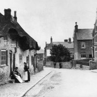
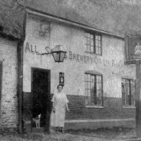
The Crown Inn on the right-hand side, is one of the four public houses in Anstey that was probably run at some time by Anstey Brewery. It is said to be Anstey’s oldest public house, possibly dating back to the 1700s.
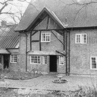
 Anstey Brewery established in the 1840s by Samuel Burchnell and later taken over by Daniel Pettifor, was built back from the road with cottages in front of it. It is now the site of Pettifor Court Retirement Complex on the left-hand side of the road.
In the 1921 census, people occupying these houses were still employed by the Pettifor family in occupations such as gardeners, waggoners and a blacksmith.
Next to The Crown were two rows of back-to-back houses, with a shared row of earth closets. They were built by the Pettifor Family for their brewery workers and were known as Pett’s front and backs. These were demolished in the 1970s and replaced with the modern houses you can see today.
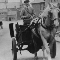 Milk came from the village farms and was delivered each morning.
The house on the right-hand side, sideways to the road, is No. 102, The Woodlands. Built around 1800, it was originally a farmstead farmed by the Astill family. Later it was owned by Daniel Pettifor of Anstey Brewery, becoming the home of his son Stanley who was a dairy farmer. Stanley’s ‘Woodlands Dairy’ was based at his farm, while his cows were grazed at various points around the village. He delivered milk around the village until 1949 when Wilf Poole of Manor Farm took over delivering the village milk.
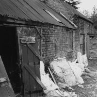 The rear of No. 84 was where Thomas Lygo, and later William Thompson, the village blacksmiths worked.
As well as shoeing horses they would have been instrumental in making and mending all kinds of tools.
Continue down Bradgate Road down the hill.
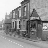 Further down, on the same side, the small extension of No. 78 was Vic Hallam’s Shoe Repairs.
 Most of the buildings on the left-hand side of Bradgate Road were cottages or shops.
One exception was the old Wesleyan Church, now a private residence. This building replaced an earlier chapel on Groby Road in 1895 and remained in use until 1940 when the church closed as a result of falling congregations and a union with the Primitive Methodist Church on Cropston Road.
It later served as a warehouse for Harris’s hardware store, which was on the other side of the road, next to the Stadon Club.
Facing Groby Lane (Road) were three cottages.At one time it is believed that a gentleman named Bill Goode lived in one of them.
He was responsible for the sewage works between Anstey and Thurcaston and was known locally as ‘Sewer Man’.
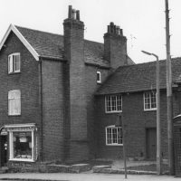
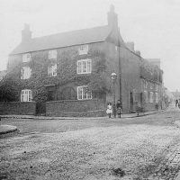 Heard Farm, on the corner with Groby Road, was built in 1767 for Mary Heard, the daughter of John Heard, a gentleman from Billesdon and his wife Ann. Mary was one of the two main landowners in Anstey.
When she died in 1803, unmarried, she left £600 to be invested and the income be divided between three parishes, Anstey being one of them. She directed that this was to be used to buy shirts and shifts for the poor.
Her large, railed tomb is in St Mary’s Churchyard.
Note the sign in the photograph for W. Lacey, Grocer, on the other corner.
 Just inside Groby Road, on the right, is the site The Limes, another farm, built in the late 16th or early 17th century.
Both farms remained as working farms until late into the 20th century.
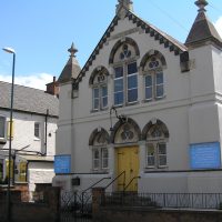 The United Reformed Church, originally known as Anstey Congregational Church, was formed in 1851. For the first three years the congregation met in in a small cottage on The Top Green, next to The Stew footpath (now marked as a public footpath next to The Crown), prior to the congregation moving to a barn on the corner of Groby Road.
In 1861 they purchased a factory, believed to be owned by Mr S Lovett, on Bradgate Road for £130 and converted it to a chapel. The present church was opened officially in 1879.
It closed in 2021 due to a dwindling congregation and it held its last service on Sunday 31st October 2021.
 On the left-hand side of Bradgate Road, just before St Mary’s Church, on the corner of Church Lane, is the site of The Plough Inn. Dating from the 1880s, it originally only served beer.
This was converted into separate dwellings and is noted for its grey stucco exterior.
Continue past Church Lane towards St Mary's Church.
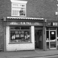 Till’s Butchers, another of Anstey’s 18th century farms, was converted to a butcher shop in 1896 to meet the needs of the expanding population.
When built, the farmhouse would have occupied both the butcher’s shop and the Chinese Takeaway next door. The farm covered the whole of the area between Church Lane and the track beyond the hairdressers, as well as the land behind.
Note the tiled frontage.
The earliest farmer/ butcher registered here is George Perkins Senior. In the 1861 census he is shown to be a butcher and grazier, employing an apprentice butcher and a servant. By the 1881 census George is farming 25 acres and employing three men, two boys and a female domestic servant
He was succeeded by his son George Jn, who was followed, in turn, by George Lowe, Harlow & Wood, Wragg’s, John Walker and now Charles Till, who took over from his father Barrie.
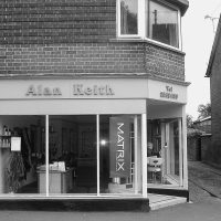 The hairdresser’s salon further down was originally built as a millinery shop, before becoming a hairdresser named Gillian’s.
In 1985 the business was taken over by Alan Keith.
 Just before the church is No. 53 Bradgate Road, at one time Anstey’s police house. In the 1890s the village policeman who lived there with his family was James Johnson. He was the grandfather of the WWII flying ace Johnnie Johnson. When James died in 1904 his family continued to live in the village and a number of them are buried in Anstey Cemetery
On the opposite side of the road, No. 58A was the slaughter house which was very important in a village with so many farms and a population that depended on local meat.
Next door, No. 58 was Pages Bakery. The bakery, established in 1880 by Walter Jones Page, was later run by his sons Tom and Walter. Walter ran this branch and Tom ran the bakery in Albion Street.
 The first village branch of the Westminster Bank was in the rented front room of the home of Eric and Adah Johnstone at No. 44. The opening hours were from 10 to 12 noon on Fridays only and was manned by a manager and a guard. The branch closed at the time of the merger with the existing National Provincial Bank in July 1968 which already had premises in The Nook.
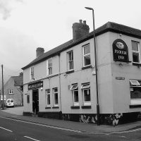
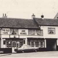 The Hare and Hounds, another of Anstey’s old public houses, pre dates the 1841 census.
Around 1843 it was the base of a female friendly society known as the United Shepherdesses. This was an insurance scheme with thirty-five rules for being allowed to join and receive benefits. Some of which were: you had to be under 35 years of age; you would not be accepted if you had had smallpox or cow pox; any member entering a workhouse or house of industry would cease to pay and not receive anything from the society.
 The housing development next door is built on Home Farm, another of Anstey’s many farms, dating back to pre-1880s.
In the 20th century it became known as Hooke’s Farm as it was run by Fred Hooke and then his son Harold.
When he died Horace Wilford took it over.
The Wilford family later farmed from Heard’s Farm and Green Farm.
No. 30, the three storeyed building among the Victorian terraced houses, was formally Anstey Post Office, run in the 1930s and 40s by Mr Goodall. The business moved into a new building on Bradgate Road where the dentist is today.
The post office is now located in the Londis store.
Continue past the church towards Anstey Nook.
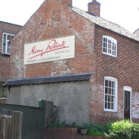 The Tannery Terrace development is built on the site previously occupied by Harry Roberts Tannery. The company, established in 1923 in Leicester, moved to Anstey in 1937 because of the number of local boot and shoe factories in the village and cheaper rates.
It was the last business of its kind in the area when it closed, and the building was demolished in 2006.
The house in front of it, now No. 16, was the home and factory of William Moore. His entry in the 1851 census is the first mention of shoe manufacturing in Anstey.
On the opposite side of the road, the ‘modern’ building that houses the dentist is built on the site that was originally Cadeby’s Farm and Cheese Dairy.
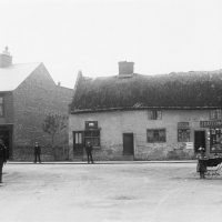
 The early 20th century brought new trades and shops to Anstey, cottages in The Nook began to adapt into shops as well as family homes.
Over the years these shops have evolved to keep up with changing times.
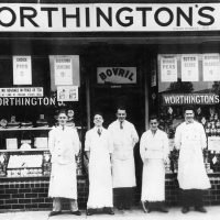
On the right- hand side, just past The Tannery was Worthington’s Grocers.
The tiles can still be seen around the shop fronts.
Opposite, the buildings were originally Rushin’s Hairdressers and later the post office.
 The chemist is one of the few shops, in Anstey, that has continued in the same trade.
Ben Thatcher was the pharmacist at the beginning of the 20th century when he built these premises in 1906. This was when the tablets etc would have been prepared on the premises, by hand.
He was succeeded by his son, Reg, in the 1930s.
Next was Roy Susman, followed by David Bradbury.
Although the shop is now run by a chain, it has remained as a dispensing pharmacy for over 125 years.
 Early 20th century shops included G.H. Moore, a cycle agent and repairer,
White’s Fish and Chip Shop, Catlow’s Stationers, Roe’s Drapers.
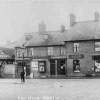 Other premises were occupied by a builder and decorator, a newsagent and the Great Central Railway Parcels Receiving Office.
 There were also a number of clothes shops in Anstey, due to the local factories and the difficulty getting to Leicester.
Many of these survived until the end of the 20th century.
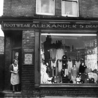
Alexanders, which was next to the Methodist Church Schoolrooms, was built in 1895 and sold boots and shoes.
In the 1930s the shop changed to selling clothing and remained into the 1970s.
 Most of the original buildings have now disappeared, but the café on the corner of Cropston Road gives an indication of how these original buildings would have looked. Even though shop fronts have changed, the roof line of many of these premises remain.
The Loros Charity Shop and Anstey Chip Shop are built on the site of the original No. 25, The Nook.
This substantial four bedroomed house belonged to the village wheelwright.
 Job Smith began this business in the 19th century and when he died it was taken over by Joseph Gray, who carried on his business in the Nook Yard, behind the house.
The business was advertised on the house wall as wheelwright, carpenter, painter, undertaker.
Although Joseph died in 1922, the company remained until 1966.
Even though Bradgate Road and The Nook were the main shopping areas, there were many other shops dotted around Anstey.
It was normal for a villager to set up shop in their front room.
Some of these were short lived, others developed into a living.
In 1970, there were 52 different businesses mentioned in a book produced to accompany a village exhibition.
A number of factory shops belonging to local companies were still open in the 1990s.
Anstey remained a self-contained village well into the 1980s when people’s shopping habits began to change.
If you look around the village there are still clues to occupations and trades in days gone by.
You have completed the Bradgate Road & The Nook- Occupations, Trades and Shopping Trail.
Time: Approx. 45 mins
To find out more about the larger companies and industries in Anstey, you can follow the relevant trails.