Sport & Entertainment Trail
Introduction to Sport & Entertainment in Anstey
For a reasonably small village, both sport and entertainment have played a large part in Anstey’s history.
Its manufacturing success resulted in a large number of sports teams and places of entertainment.
As well as the larger sports which the trail concentrates on, many smaller games, sports and activities took place in the village pubs and clubs.
Darts, dominoes, billiards, snooker and table skittles are just some of the leagues in which Anstey pubs, clubs and factories took part against each other.
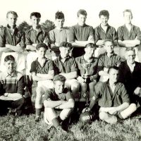
Anstey has produced a number of well-known sportsmen.
Willie Thorne, the snooker player, was born in 1954, in a house, which was just behind where the Passage to India is now.
He learnt to pay snooker in the Conservative Club on Stadon Road when his father was steward in the 1960’s.
He went on to have a long career as a snooker player and later as a commentator, he was known as ‘Mr Maximum’ as he was the first played to achieve 100 century breaks.
Willie died in 2020 at the age of 66
Daniel Greaves (Discuss Dan) was born in Anstey in 1982 and is a United Kingdom para discus thrower.
Between 2000 and 2023 Dan won 1 gold, 2 silver and 3 bronze medals in the Paralympics; 3 gold, 1 silver and 1 bronze in the World Championships; 4 gold medals in the European Championships and 1 gold in the Commonwealth championships.
When Dan won Bronze at the 2020 Summer Paralympics in Tokyo, he became the first British track and field athlete to win medals at six consecutive Paralympic Games.
Although many of the clubs and societies have disappeared, Anstey still has many places to eat and drink and sport plays an important part in village life.
It is your responsibility to be aware of whether you are allowed to access any area, to follow the Highway Code, and to be observant of any hazards which may be present along or near your route.
If you experience any issues while following the trail please Contact Us and provide a description.
We hope you enjoy the trail and we would really appreciate your feedback.
Map showing Start of Trail
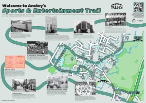
The board for this trail is installed in the car park for Mitchells Field, opposite the Anstey Nomads football ground.
Map view of the Sports & Entertainment Trail starting point
Street view of the Sports & Entertainment Trail
Clicking the links will either open a new tab on your browser or the Google Maps app
New Feature: You can now click on any of the images for this trail to view a full sized photograph on screen in a lightbox, and click again to close it.
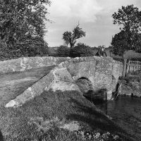
Begin the trail on King William’s Bridge, which is at the end of Sheepwash Lane, off Cropston Road, outside The Anstey Nomads Football Ground.
 The lane you are standing in, was originally a route from Leicester to Bradgate Park.
This bridge is known as Sheepwash Bridge, King William’s Bridge or The Dambridge.
It is believed that the brook was dammed at this point and used as a sheep wash. Recent excavations show possible evidence of this.
When William III decided to visit the Grey Family at Bradgate House in 1696 it was realised that neither of the bridges into Anstey were wide enough for the king’s coach to pass over. It was decided this would be the easier bridge to widen hence the name, King William’s Bridge.
The footpath that continues to the left, over the bridge into Castle Park, was originally intended, in the Enclosure Act of 1761, to be the main road to Thurcaston.
Return towards Cropston Road and stop outside The Anstey Nomads Football Ground.
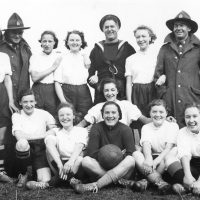
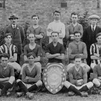 Football has always been an important pastime in Anstey for both men and women and very much a way of bonding.
Prior to WWII many football clubs existed in the village.
Some of these were Town, United, Athletic, Council Adult School, Congs (Congregational Church), Adult School, St Mary’s (Church) and PM (Primitive Methodist Church).
There were also teams formed from members of the boot and shoe factories.
 In 1947, two clubs, St Mary’s and the P.M. decided to join forces under the name of Anstey Meths and St Marys.
After one season the name was changed to the Nomads.
After playing on several fields in the village, the Nomads settled at their present ground on Cropston Road.
 By 1955 the lease on the ground had expired and the Nomads were faced with the prospect of raising £1000 to buy the land. A sweepstake was held and the money raised.
The field on the opposite side of the lane is called Mitchell’s Field after Mitchell Pickering, an Anstey schoolboy who lived nearby, sadly died of an asthma attack.
At the end of Sheepwash Lane, with your back to The Nomads ground, turn left onto Cropston Road and walk towards the village centre.
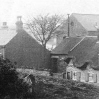
 On the left-hand side, opposite Hope Cottages, was ‘Plum Ford’.
One of the meanders of the Anstey Brook came right up to the road at this point and for decades it was a popular crossing point for the villagers and a playground for children. The brook was realigned in the early 1960s to help prevent flooding and the site is now used as a garage.
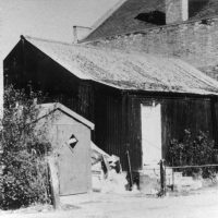
In the early 1950s, Anstey had two speedway teams. One, The Savoy Stars, was situated on the field where the garage and Broughton’s extension are now.
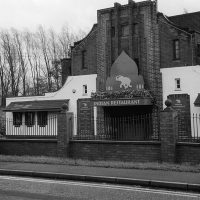
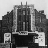 Continue along Cropston Road towards the village centre. On your left is Broughton’s Ironmongery Shop, the site of The Savoy Cinema, one of two cinemas in Anstey.
The cinema was originally called The Coronet. The building of the cinema was completed in 1937, the year of the coronation of King George VI and Queen Elizabeth.
Built by local businessman and entrepreneur Mr. Albert (Bert) Baum, it was owned by him and Jack Fisher. Mr. Baum would travel to Birmingham on his motorbike three times a week to get new films and news reels.
 By 1950 the Coronet Cinema had been renamed the Savoy Cinema, and was owned by Mr G.T. Ball of Blaby and later by W. Barker and A.A. Toy.
The Savoy Cinema closed in the 1960s and was converted into a garage and filling station which closed in 1988.
Two side extensions were added, and the building re-opened as the ‘Savoy Diner’ in 1990. In a nod to the past, customers could watch silent films while dining. It then became an Indian restaurant, ‘The Pink Elephant’ before Broughton’s took over the premises in 2002.
Continue along Cropston Road until you reach The Nook which is now the main focus of the village.
 The Nook originally joined Anstey’s two main roads – Main Street (now Bradgate Road) and Cropstone Road (now Cropston Road).
The 1761 enclosure map of Anstey shows a small structure marked in the centre of the Nook where the roundabout is today and labelled “Stamford”. There is no record of what this building was, but speculation is that it could have been a market hall or cheese market.
More probably it was a lock up; somewhere to hold people until they were able to be removed to a court or to hold drunks overnight until they were released next day.
The Earl of Stamford was a major landowner in the area at this time.
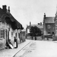
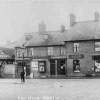 Until the 1920s The Nook was a wide-open space surrounded by cottages and shops, often used as a playground by the children of the village. Over the years it has replaced Main Street (Bradgate Road) as the focus of the village.
The early buildings around The Nook were cottages, many of them thatched. A number of these were built with steps to prevent them being flooded. These later became shops in the early 20th century and most of the shop keepers lived over the premises.
Most of these buildings have now disappeared, but the café on the corner of Cropston Road gives an indication of how the original buildings would have looked. Even though some shop fronts have changed, the roof line of many of these premises remain.
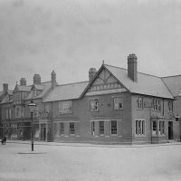 The Coach and Horses public house, built in its present form around 1895 when the business was taken over by Marstons Brewery and the much earlier building, predating the 1841 census, was demolished.
Part of the car park was originally the stables for horses
Leave The Nook and walk up Stadon Road.
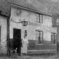
 On the left- hand side was Anstey Working Men’s Club, founded around the 1880s
It was originally part of the Pettifor’s Steam Brewery Company on Main Street (now Bradgate Road), becoming part of Marstons when the brewery was taken over in 1900,
In the 1920s the Working Men’s Club committee applied to Marstons to take over the property and it was successful.
Working men’s clubs were popular right up until the 1970s. They were usually packed at the weekend when bingo and a pint were on offer.
Dads were often tasked to take the children there while Mum got on and cooked the Sunday lunch.
The current building now houses the Sapori Restaurant and became famous for hosting the Leicester City Football Club manager, Claudio Ranieri and the Premier League team on several occasions during the season when they had their famous 5000-1 Premier League win in 2016.
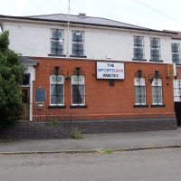 Further up the road, Anstey Conservative Club was another of Anstey’s clubs for ‘like-minded’ people.
It was here that a young Willie Thorne learnt to play snooker.
Next to the former Conservative Club are some 1970s houses.
 This is the site of Anstey’s 2nd speedway track.
The team, formed in the 1950s, originally called themselves Woodgon Peckers, as the field was where Woodgon Road then stopped.
The land belonged to George Harry Palmer who lived in The Hollies opposite and owned Palmers Shoe Factory on the corner of Highfield Street.
When he gave the group a donation, they changed their name to Palmers Pirates.
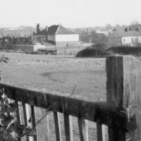
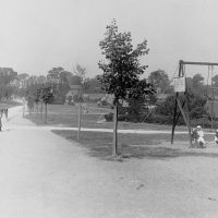
 The large field on the left, is known by all Anstey folks as The Reccy.
Villagers fought for many years to have a recreation ground in the village. Even though the subject was mentioned in Parish Council documents as far back as 1928, it was not until 1952 that land was purchased for this purpose. It cost the parish £1,400 which included piping the ditch that had run across the field for many years and levelling out the ridge and furrows.
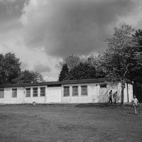
There was once a cricket pitch on the Reccy; notice the back of the Jubilee Hall, it was designed with a covered corridor to offer shelter for spectators and it also houses changing rooms.
This was the home of Anstey Cricket Club until it moved to Glenfield and merged with Glenfield Cricket Club.
Cricket teams had existed in Anstey since the late 1800s, most connected to the churches, social clubs and factories.
 The new Jubilee Hall was built in 2003 to replace the original Memorial Hall, which had stood on the same site.
The Jubilee Hall was extended in 2024.
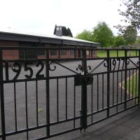
The gates were erected in 1977 to celebrate the Silver Jubilee of Queen Elizabeth II.
 Every year the Anstey Gala is held on the field.
This is a chance for the whole village to come together.
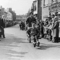
In the 1950s and 60s the highlight of Gala Day was a wheelbarrow race, or ‘The Barrow Race’ as it was known to the villagers.
The roads in the village were closed and races were held.
Teams of two pushed each other round a course in a wheelbarrow. The races began near The Martin School on Link Road and finished in The Nook.
The competitors changing places half way round.
In addition, there was a Gala Parade when local groups, factories and organisations entered floats and the Anstey Gala Queen was crowned.
Continue walking up Stadon Road until you reach the junction with Hollow Road. Cross over the road to Ellis Street.
 The short street in front of you was, until 1899, known as Martin Ellis Street, named after two of Anstey‘s most prominent families. After this date the Martin name was dropped.
The Martin’s were wealthy landowners; the Ellis’s were not only wealthy, but were also liberal, as was the majority of Anstey at the time and it is believed that this is the reason the name was changed.
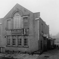
The building called Regent House, on the left-hand side of Ellis Street, was the second of Anstey’s two cinemas.
The cinema was originally known as The Picture House, which showed silent films. It was a corrugated iron building with wooden benches and was opened and run by Mr F. Grimsley.
In 1938 it was rebuilt in its present form by Mr and Mrs Rodwell and renamed The Regent. It finally closed down in 1959.
The cinema was known by the villagers as ‘Up Top’ as opposed to The Savoy which was ‘Down Bottom’.
Retrace your steps to the junction with Hollow Road. Turn right and follow the road to the end when you reach a large grassed area.
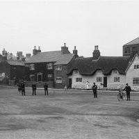
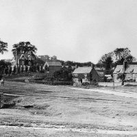 This area is one of Anstey’s two ‘greens.’ Known as The Green or The Top Green it was originally a main focus of the village.
The area was mentioned on the Enclosure Map of 1761 when it was common land.
Originally very rural, The Green was surrounded by farms and cottages, some thatched and some slated, some dating to the 15th century. The large Georgian house in front of you being an exception.
In the centre of the green is the village well. It is believed that the wall surrounding it is medieval.
 This area was a playground for the village children and at the beginning of the 20th century swings were installed.
Not everyone was happy about this and the Parish Council discussed complaints at numerous meetings.
The police were asked to keep an eye on them, they were only for under 14s and not to be used on Sundays.
From The Green, turn left and walk down Bradgate Road.
 Originally named Main Street, Bradgate Road was the main street through the village, joining one way with what is now Cropston Road through the Nook and the other way as Newtown Lane towards Newtown Linford.
Until the latter part of the 19th century, this area would have been very rural, just fields and farms interspersed with cottages.
It was from this main road that most of the village roads radiated .St Mary’s Church was the centre of the medieval village.
Most of the population originally lived here; the village only expanding with the coming of the boot and shoe industry in the 19th century.
A number of the original buildings remain, although most now have different uses; many being renovated for residential use.
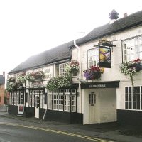
 On the right is The Crown, believed to be the oldest public house in Anstey, possibly dating back to the 1700s.
Like the other public houses in the village, it was run by Anstey’s Steam Brewery.
 The brewery, established in the 1840s by Samuel Burchnell was later taken over by John Doleman and finally by Daniel Pettifor.
In 1900 the business and property in front of it was taken over by Marstons Brewery.
The site is now Pettifor Court Retirement Complex.
Follow the road until you reach a grey building on your left. Here, turn into Church Lane.
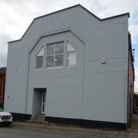
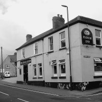 The grey building on the corner of Church Lane is the site of The Plough Inn. Dating from the 1880s, it originally only served beer.
It has now been converted into separate dwellings and is noted for its grey stucco exterior.
Church Lane, one of the ancient roads in Anstey, is situated next to the church and was part of the medieval centre of the village.
 Many of the surviving houses in Church Lane were built in the late 19th or early 20th century for the growing population of workers in the village boot and shoe industries. There were a number of alleys and yards leading off, with names such as Kidney Bean Alley, Wells Yard and Clarkes Yard as well as Papermill Row. A large number of these houses have now been replaced with modern builds. However, enough remain to give an idea of what the area would have been like. The numbering of the houses indicates how many of the original have disappeared since 1923.
 The house next to the churchyard was the curate’s house. The Adult School opposite, was formed in 1895 as somewhere men could go to progress their education. This was especially useful for those men who had left school at an early age or only attended school part time, due to work commitments.
In 1900 it was decided that Anstey needed a place where men could meet on work nights, instead of going to the public houses.
The building was bought for the village and over £100 was raised for its renovations.
As well as a place of education, it became somewhere for socialising, especially on Sunday evenings.
It later had sporting teams, a billiard table and other sports related events as well as regular dances.
Follow Church Lane to the bottom. Before you cross over Bradgate Road at the traffic lights, make a short detour to your right until you reach the bend.
 Looking across the road is The Old Hare and Hounds, another of Anstey’s old public houses, which was a coaching inn pre dating the 1841 census. It was also owned by Pettifor’s Steam Brewery until 1900 when Marstons took over the brewery.
Around 1843 it was the home of a female friendly society known as the United Shepherdesses. This was an insurance scheme, with thirty-five rules needed to join and receive benefits. Some of these were:
You had to be under 35 years of age; you would not be accepted if you had had smallpox or cow pox; any member entering a workhouse or house of industry would cease to pay and not receive anything from the society.
Return to follow The Jetty, between the two housing developments to Latimer Street. Then turn right.
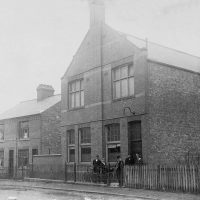
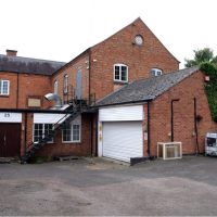
 The first building you reach, Lilliput Montessori Nursery, was formerly Anstey Liberal Club, dating from around 1923.
Football, cricket, darts, skittles were just a few of the sports that were associated with the club and leagues soon developed.
It was also the meeting place for Anstey’s’ pigeon fanciers and it was common place to see men sitting outside waiting for their birds to return from a race.
Next door was the Anstey Toc H building.
 Toc H was established in 1915 by an army chaplain, Rev Tubby Clayton, who was instructed by his senior chaplain to set up a rest home for troops in France which opened on 11th December 1915.
The work continued after the war as a society whose members sought to ease the burdens of others through acts of service. They also promoted reconciliation and worked to bring sections of society together.
The present building was built on the site of the previous Toc H Hut, which was erected in the early 1930s. It was incorporated into Lilliput Nursery in the early 21st century
Many Anstey residents remember the Christmas morning house to house collections around the village, raising money for the Toc H summer outings for Anstey’s older residents.
Follow the lane between the school buildings to the area of green at the bottom.
 This is the Lower or Bottom Green, another of Anstey’s two ‘Greens’.
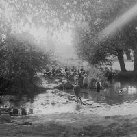
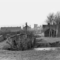
The Anstey (Rothley)Brook runs through here and there are two bridges to be seen.
The stone bridge spanning the brook is the Packhorse Bridge and is one of two such bridges that are found in Anstey. You have already seen King William’s Bridge at the beginning of the trail.
One of the oldest structures in the village, it is believed to date from around 1500, although the track itself is probably much earlier.
It is one of the best-preserved packhorse bridges in Britain. Note the V shaped features which enabled people to move out of the way of the laden horses as they passed. Hence its name.
It was on the fields surrounding this area that the yearly Wakes happened.
This was a highlight of the village year when the fair arrived.
It was always the same week, the schools closed and everyone in the village would attend.
The tradition of the fair coming to Anstey survived until the end of the 20th century.
Cross over the main road. You may wish to turn left back into the village centre and finish the trail here. Alternatively, follow the road out of Anstey to where the path forks. Take the left -hand path. Until the A46 was built in the 1990s this was the main road to Leicester. Follow the road until you reach Gynsill Tennis Club on your right.
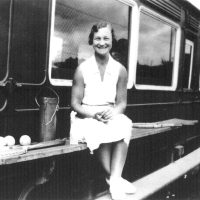 In the 1920s, Fred Wain, managing director of Pollard and Wain Shoe Company (later Airborne Shoes), bought land and built tennis courts on the site of today’s Gynsills Tennis Club. It was known as Airborne Sports Club.
A 1920s railway carriage was acquired for a clubhouse and this was still in use in the 1950s.
The Gynsill Lawn Tennis Club was formed in 1963.
You have completed the Sport and Entertainment Trail
Time: Approx. 1 hour